

- Usage in publication:
-
- Detroit till
- Detroit glacial stage
- Modifications:
-
- Original reference
- Dominant lithology:
-
- Till
- AAPG geologic province:
-
- Western Columbia basin
Summary:
Pg. 20, 23-24. Detroit glacial stage defined as time during which Detroit till was deposited. All exposures of till are small. Age is Pleistocene.
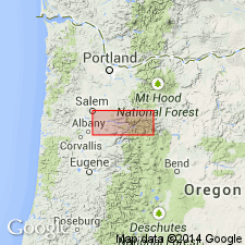
Till crops out in North Santiam River just above bridge and on Quartzville Trail, in a roadcut 0.5 mi southwest of Berry, where highway crosses Breitenbush River southwest of Detroit, Marion Co., northwestern OR.
Source: US geologic names lexicon (USGS Bull. 1200, p. 1101).
For more information, please contact Nancy Stamm, Geologic Names Committee Secretary.
Asterisk (*) indicates published by U.S. Geological Survey authors.
"No current usage" (†) implies that a name has been abandoned or has fallen into disuse. Former usage and, if known, replacement name given in parentheses ( ).
Slash (/) indicates name conflicts with nomenclatural guidelines (CSN, 1933; ACSN, 1961, 1970; NACSN, 1983, 2005, 2021). May be explained within brackets ([ ]).