

- Usage in publication:
-
- Dell Tuff*
- Modifications:
-
- Original reference
- Dominant lithology:
-
- Tuff
- AAPG geologic province:
-
- Great Basin province
Summary:
Dell Tuff. Gray to pink rhyolitic ash-flow tuff. Chiefly crystals of quartz, sanidine, biotite, and plagioclase in a poorly welded to unwelded matrix of devitrified shards and pumice. Thickness 180 m. Unconformably overlies Drum Mountains Rhyodacite, or locally overlies Oligocene(?) breccia at Spor Mountain or Paleozoic rocks; unconformably underlies Spor Mountain Formation. Age is Oligocene, based on average fission-track age of 32 Ma.
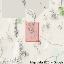
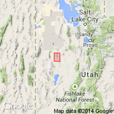
Type locality: The Dell, in secs. 23 and 24, T. 12 S., R. 12 W., Thomas Range, Juab Co., western UT. Named from The Dell.
Source: US geologic names lexicon (USGS Bull. 1564, p. 44-45).
- Usage in publication:
-
- Dell Tuff*
- Modifications:
-
- Areal extent
- Geochronologic dating
- AAPG geologic province:
-
- Great Basin province
Summary:
Is an Oligocene unit--a simple cooling unit--limited to Thomas Range and Key Mountains, in the Great Basin province. Has an average isotopic age of 32.0+/-0.6 Ma.
Source: GNU records (USGS DDS-6; Denver GNULEX).
For more information, please contact Nancy Stamm, Geologic Names Committee Secretary.
Asterisk (*) indicates published by U.S. Geological Survey authors.
"No current usage" (†) implies that a name has been abandoned or has fallen into disuse. Former usage and, if known, replacement name given in parentheses ( ).
Slash (/) indicates name conflicts with nomenclatural guidelines (CSN, 1933; ACSN, 1961, 1970; NACSN, 1983, 2005, 2021). May be explained within brackets ([ ]).