The National Geologic Map Database is migrating to a new infrastructure. We apologize for any service disruptions during this process.
|
|---|


- Usage in publication:
-
- Delamar Lake Tuff*
- Modifications:
-
- Named
- Geochronologic dating
- Dominant lithology:
-
- Tuff
- Volcanics
- AAPG geologic province:
-
- Great Basin province
Summary:
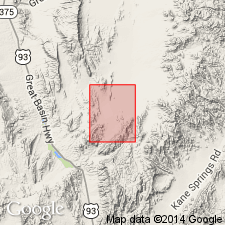
Delamar Lake Tuff is named for Delamar Lake in the Delamar Lake 7.5' quad, Lincoln Co, NV. Composite type section is located in the central and northern part of the Delamar NW 7.5' quad, and consists of individual measured sections for each of the cooling units comprising the formation (ascending): 1) lower cooling unit best exposed in the section whose base is located at lat. 37deg28.10'N, long. 114deg58.11'W; 2) crystal-rich cooling unit best exposed in the section between the base located at lat. 37deg25.19'N, Long. 114deg59.79'W and the top located at Lat. 37deg25.28'N, long. 114deg59.65'W; 3) pumice-rich cooling unit best exposed in the section at lat. 37deg25.29'N, long. 114deg59.59'W; 4) orange cooling unit best exposed on a north-trending ridge at lat. 37deg29.43'N, long. 114deg56.49'W. Consists of rhyolite ash-flow tuff comprising two simple cooling units and an underlying non-welded tuff in the Delamar Lake 7.5' quad; also includes thin-bedded tuffs, locally. [Consists of four cooling units in the Delamar NW 75. quad.] Thickness ranges to as much as 190 m in the north part of the Delamar Lake 7.5' quad. Overlies an unnamed basalt (flow) unit; conformably underlies the Sunflower Mountain Tuff (new). Age is Miocene based on K-Ar (sanidine) age of 15.6 +/-0.4 Ma.
Source: GNU records (USGS DDS-6; Menlo GNULEX).
For more information, please contact Nancy Stamm, Geologic Names Committee Secretary.
Asterisk (*) indicates published by U.S. Geological Survey authors.
"No current usage" (†) implies that a name has been abandoned or has fallen into disuse. Former usage and, if known, replacement name given in parentheses ( ).
Slash (/) indicates name conflicts with nomenclatural guidelines (CSN, 1933; ACSN, 1961, 1970; NACSN, 1983, 2005, 2021). May be explained within brackets ([ ]).