

- Usage in publication:
-
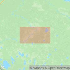
- Deer Lake Complex
- Modifications:
-
- Original reference
- Dominant lithology:
-
- Peridotite
- Clinopyroxenite
- Gabbro
- Diorite
- AAPG geologic province:
-
- Sioux uplift
Summary:
Three layered sills, each intruded along upper contact of previous one; each magma injection fractionated into sequence of ultramafic to dioritic rocks. Thickness 430 m. Conformably intrudes early Precambrian metabasalt and metasedimentary rocks; cut by middle Precambrian(?) gabbroic dikes. Age is Precambrian.
Type locality: northeast-trending band 10 km long and 2.5 km wide, in T. 61 and 62 N., R. 24 and 25 W., 4 km southwest of Deer Lake and 6.5 km northeast of Bigfork, Itasca Co., north-central MN.
Source: US geologic names lexicon (USGS Bull. 1564, p. 44).
For more information, please contact Nancy Stamm, Geologic Names Committee Secretary.
Asterisk (*) indicates published by U.S. Geological Survey authors.
"No current usage" (†) implies that a name has been abandoned or has fallen into disuse. Former usage and, if known, replacement name given in parentheses ( ).
Slash (/) indicates name conflicts with nomenclatural guidelines (CSN, 1933; ACSN, 1961, 1970; NACSN, 1983, 2005, 2021). May be explained within brackets ([ ]).