

- Usage in publication:
-
- Deer Lake conglomerates*
- Modifications:
-
- First used
- Dominant lithology:
-
- Conglomerate
- Schist
- AAPG geologic province:
-
- Lake Superior region
Summary:
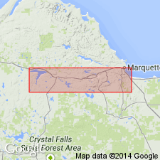
Is first used to describe a "conglomeratic" phase of the Archean Kitchi schists (new) in the vicinity of Deer Lake, northwest of Ishpeming, Marquette Co, MI (Lake Superior region). "Many of the green schists of the Northern Complex are noticeable for the pebble and bowlder-like bodies scattered through them. These fragments stand out so plainly in the weathered surfaces of the exposures on the Kitchi Hills in the vicinity of Deer Lake that they may be seen at long distances. They are usually so well rounded that the rock containing them looks very much like a sedimentary conglomerate. Indeed, so conglomeratic are their features that they have frequently been called the "Deer Lake conglomerates." Kitchi schists are mapped (pl XIII) in east-west belt (2 to 3.5 miles wide) from east line of R27W to west line of secs 25 and 36; are thought to pass into Mona schists (new) to east; in contact with coarse gneissoid granite to west; bounded to north by Algonkian deposits of Silver Lake area and to south by those of Marquette range.
Source: GNU records (USGS DDS-6; Reston GNULEX).

- Usage in publication:
-
- Deer Lake Peridotite*
- Modifications:
-
- Overview
- Areal extent
- AAPG geologic province:
-
- Lake Superior region
Summary:
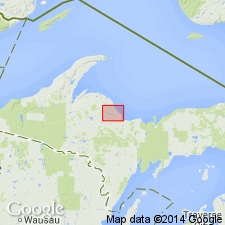
Present in Marquette district of northern MI in Lake Superior region. Is Late Archean in age.
Source: GNU records (USGS DDS-6; Reston GNULEX).
- Usage in publication:
-
- Deer Lake Peridotite*
- Modifications:
-
- Overview
- AAPG geologic province:
-
- Michigan basin
Summary:
According to the authors, most of the peridotite is dark gray to green and composed of fine-grained serpentine with minor opaque oxides. Cumulate textures indicate an intrusive origin. The peridotite has high MgO, typical of intrusive ultramafics. Conformable contacts along with intrusive textures, support Brozdowski's (1989) conclusion that the Deer Lake is a sill complex.
Source: GNU records (USGS DDS-6; Reston GNULEX).
For more information, please contact Nancy Stamm, Geologic Names Committee Secretary.
Asterisk (*) indicates published by U.S. Geological Survey authors.
"No current usage" (†) implies that a name has been abandoned or has fallen into disuse. Former usage and, if known, replacement name given in parentheses ( ).
Slash (/) indicates name conflicts with nomenclatural guidelines (CSN, 1933; ACSN, 1961, 1970; NACSN, 1983, 2005, 2021). May be explained within brackets ([ ]).