The National Geologic Map Database is migrating to a new infrastructure. We apologize for any service disruptions during this process.
|
|---|


- Usage in publication:
-
- De Smet formation
- Modifications:
-
- Original reference
- Dominant lithology:
-
- Schist
- AAPG geologic province:
-
- Midcontinent region
Summary:
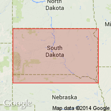
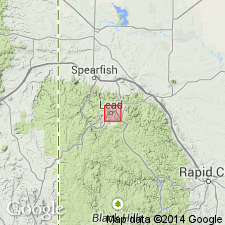
Pg. 793-799, 836-843, with maps. De Smet formation. Garnet schist, alternating light and dark bands, micaceous, fibrous, thinly foliated, bumpy. Most of schist is green to dark-gray. Thin films of pyrite parallel to the schistosity indicative of two periods of folding. Thickness 300 feet. Underlies Homestake formation; contact is sharp and distinct. Gradationally overlies Poorman formation. Mapped as a thin band north and west of Lead, South Dakota. Age is Precambrian. Believed to be Keewatin age (Archean). Report includes geologic map.
Named from plentiful exposures around north end of main open cut southwest of De Smet shaft, Homestake Mine area, Lead district, Lawrence Co., southwestern SD.
Source: US geologic names lexicon (USGS Bull. 896, p. 602); supplemental information from GNU records (USGS DDS-6; Denver GNULEX).
- Usage in publication:
-
- De Smet formation
- Modifications:
-
- Not used
Summary:
Pg. 945. De Smet formation. Does not maintain constant position; may be absent or occur at one or several positions. Name De Smet dropped as separate formation; unit included in Poorman formation.
Source: US geologic names lexicon (USGS Bull. 1200, p. 1098).
For more information, please contact Nancy Stamm, Geologic Names Committee Secretary.
Asterisk (*) indicates published by U.S. Geological Survey authors.
"No current usage" (†) implies that a name has been abandoned or has fallen into disuse. Former usage and, if known, replacement name given in parentheses ( ).
Slash (/) indicates name conflicts with nomenclatural guidelines (CSN, 1933; ACSN, 1961, 1970; NACSN, 1983, 2005, 2021). May be explained within brackets ([ ]).