The National Geologic Map Database is migrating to a new infrastructure. We apologize for any service disruptions during this process.
|
|---|


- Usage in publication:
-
- Daylight Formation*
- Modifications:
-
- Original reference
- Dominant lithology:
-
- Shale
- Siltstone
- AAPG geologic province:
-
- Great Basin province
Summary:
Pg. J2-J3, pls. 1, 2. Daylight Formation. Predominantly clastic rocks. Micaceous shale and siltstone most abundant, but interbedded quartzitic sandstone beds common. Limestone and dolomite beds as thick as 50 feet occur at intervals, particularly in upper and lower parts. An arkosic conglomeratic quartzite as thick as 500 feet present near middle of formation. In upper 500 feet are quartzitic sandstone beds interbedded with siltstone, and some of sandstone beds contain vertical rods, perpendicular to bedding, that have been identified as SCOLITHUS [SKOLITHOS]. In upper part of formation are one to three closely spaced beds of yellow to brown oolitic to pisolitic limestone and dolomite. The oolitic limestone or dolomite is persistent marker zone; it occurs about 800 feet below top of formation in unfaulted Bare Mountain section, but in Bullfrog quadrangle [this report] the overlying Corkscrew Quartzite (new) is faulted over Daylight Formation and most or all of the shale and siltstone above the oolite may be missing. Thickness about 4,000 feet on Bare Mountain, Nye County, Nevada. Formation was first studied on Bare Mountain and was originally considered part of Johnnie(?) Formation (Cornwall and Kleinhampl, 1960, GSA Bull., v. 71, no. 12, pt. 2, 1960, USGS Min. Inv. Field Studies Map MF-177, 1960, USGS Geol. Quad. Map GQ-157). Present indications favor correlation with Wood Canyon Formation. Age is Cambrian.
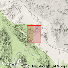
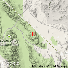
Named from exposures in southwestern part of Bullfron quadrangle where Daylight Pass is located in sec. 36, T. 13 S., R. 46 E., Inyo Co., eastern CA.
Source: US geologic names lexicon (USGS Bull. 1350, p. 195).
- Usage in publication:
-
- Daylight Formation*
- Modifications:
-
- Areal extent
- AAPG geologic province:
-
- Great Basin province
Summary:
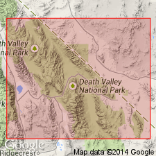
Wood Canyon Formation conformably overlies Stirling Quartzite and is recognized throughout the Spring Mountains and Death Valley region. In Bare Mountain and Bullfrog quadrangles Cornwall and Kleinhampl (1964) applied name Daylight Formation to the rocks here considered to be Wood Canyon Formation. Use of name Daylight Formation is confined to these quadrangles.
[GNC remark (ca. 1970, US geologic names lexicon, USGS Bull. 1350, p. 195): The USGS has abandoned term Daylight Formation on basis on study now in progress (see Stewart, 1970). Term Wood Canyon Formation extended and used in preference to term Daylight.]
Source: US geologic names lexicon (USGS Bull. 1350, p. 195).
- Usage in publication:
-
- Daylight Formation†
- Modifications:
-
- Abandoned
- AAPG geologic province:
-
- Great Basin province
Summary:
†Daylight Formation (Precambrian and Early Cambrian) abandoned. Its rocks reassigned to Wood Canyon Formation.
Source: Changes in stratigraphic nomenclature, 1970 (USGS Bull. 1354-A, p. A6-A7).
For more information, please contact Nancy Stamm, Geologic Names Committee Secretary.
Asterisk (*) indicates published by U.S. Geological Survey authors.
"No current usage" (†) implies that a name has been abandoned or has fallen into disuse. Former usage and, if known, replacement name given in parentheses ( ).
Slash (/) indicates name conflicts with nomenclatural guidelines (CSN, 1933; ACSN, 1961, 1970; NACSN, 1983, 2005, 2021). May be explained within brackets ([ ]).