

- Usage in publication:
-
- Dawson Bay formation
- Modifications:
-
- Named
- Dominant lithology:
-
- Shale
- Limestone
- Dolomite
- Anhydrite
- AAPG geologic province:
-
- Williston basin
Summary:
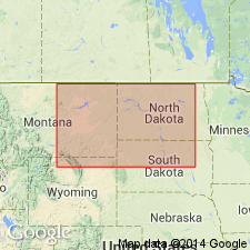
Named as the basal formation of Manitoba group (new). Lower contact conformable with the Prairie evaporite formation (new) of the Elk Point group (rank raised) is placed at base of red and green shale. Upper contact with an unnamed part of the Manitoba is placed at top of a reefoid and stromatoporoid limestone. Occurs on the Manitoba shelf of central SA and southwest MB of CN and south into MT, ND, and SD in the Williston basin. Correlation chart; cross sections; description of well samples. Southwest of the Swift Current platform in south-central MB, the Dawson Bay is very thin (<20 ft) and cannot be separated from the underlying Elk Point. Type area is Dawson Bay at north end of Lake Winnipegosis, MB, CN. Composite section measured in Ts44 and 45, R25W, where formation consists of brown-red to gray shale (base) and yellowish-gray, dense to finely crystalline, finely laminated, argillaceous, fossiliferous (crinoids, brachiopods) limestone 151 ft thick. Ranges from 100 to 200 ft thick regionally. Fossil fragments--especially corals and stromatoporoids; reef-complex suggested. Anhydrite (as much as 20 ft thick) or anhydritic dolostone is present in the subsurface above the limestone. Bituminous matter also identified. Correlated with upper part of Maywood formation of MT. Assigned to the Middle Devonian.
Source: GNU records (USGS DDS-6; Denver GNULEX).
- Usage in publication:
-
- Dawson Bay formation*
- Modifications:
-
- Areal extent
- Overview
- AAPG geologic province:
-
- Williston basin
Summary:
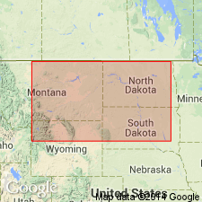
Name defined in MB, CN and applied to rock above Prairie formation of Elk Point group and beneath Souris River formation in the subsurface of the Williston basin. Areal extent map shows the formation in ND and adjacent northeast MT. Divided into an argillaceous member, 10-20 ft thick that consists of brown or gray red dolomitic siltstone (or silty argillaceous dolomite) interbedded with argillaceous limestone and dolomitic shale, and a carbonate member 100-150 ft thick that consists of finely crystalline porous dolomite or limestone, anhydritic in the upper part. Its uniform lithologic character makes it difficult to pick in subsurface. Cross section. Correlation chart. Of Middle Devonian age.
Source: GNU records (USGS DDS-6; Denver GNULEX).
For more information, please contact Nancy Stamm, Geologic Names Committee Secretary.
Asterisk (*) indicates published by U.S. Geological Survey authors.
"No current usage" (†) implies that a name has been abandoned or has fallen into disuse. Former usage and, if known, replacement name given in parentheses ( ).
Slash (/) indicates name conflicts with nomenclatural guidelines (CSN, 1933; ACSN, 1961, 1970; NACSN, 1983, 2005, 2021). May be explained within brackets ([ ]).