The National Geologic Map Database is migrating to a new infrastructure. We apologize for any service disruptions during this process.
|
|---|


- Usage in publication:
-
- Dantzler formation
- Modifications:
-
- Original reference
- Dominant lithology:
-
- Sand
- Shale
- AAPG geologic province:
-
- Mid-Gulf Coast basin
Summary:
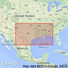
Pg. 477 (table), 478. Dantzler Formation. Defined as the sand and gray and red-mottled shale section, with fossiliferous zones, which intervenes between base of lower Tuscaloosa and top of Washita limestone. Thickness 105 feet in type well. Age is Early Cretaceous (Comanche).
Type section (subsurface): depth-interval 8,905 to 9,910 ft, Humble Oil and Refining Company B-1 Dantzler well, Jackson Co., MS. Recognized in subsurface of Mississippi and Louisiana, notably in wells in Forest, Jefferson Davis, Lamar, Lawrence, Marion, and Stone Cos., MS, and in Washington Parish, LA.
Source: US geologic names lexicon (USGS Bull. 1200, p. 1042); supplemental information from GNU records (USGS DDS-6; Reston GNULEX).
For more information, please contact Nancy Stamm, Geologic Names Committee Secretary.
Asterisk (*) indicates published by U.S. Geological Survey authors.
"No current usage" (†) implies that a name has been abandoned or has fallen into disuse. Former usage and, if known, replacement name given in parentheses ( ).
Slash (/) indicates name conflicts with nomenclatural guidelines (CSN, 1933; ACSN, 1961, 1970; NACSN, 1983, 2005, 2021). May be explained within brackets ([ ]).