

- Usage in publication:
-
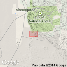
- Danley Ranch tongue*
- Modifications:
-
- Named
- Dominant lithology:
-
- Siltstone
- Sandstone
- Limestone
- AAPG geologic province:
-
- Orogrande basin
Summary:
Named as a tongue of Abo sandstone for section 1 mi east of Danley Ranch headquarters, Orogrande basin, Otero Co., south-central NM; type section designated in SW1/4 sec 35, T19S, R11E. Cannot be traced south of southern Sacramento Mountains. Composed predominately of soft red shale, reddish brown, cross-laminated shaly siltstone, very fine-grained sandstone, with thin ledges olive-gray limestone which may be tongues of Hueco. Four types of conglomerate derived from local sources present in lower part: 1) granules and pebbles of quartzite and fragments of rhyolite porphyry; 2) limestone boulder containing slabs of Pennsylvanian limestone in a matrix of reddish-brown, coarse-grained, angular to sub-angular, arkosic sandstone; 3) subrounded pebbles and cobbles of limestone in a calcareous sandstone matrix; 4) angular chert fragments (to 10 inches in diameter) in a reddish-brown, fine-grained matrix (probably an iron-rich carbonate). Varies widely in thickness; averages 100 ft thick; nearly 200 ft thick 1 mi south of sec 30, T20S, R11E. Overlies Pennsylvanian Magdalena group with sharp unconformity; underlies and intertongues with Hueco limestone. Is unfossiliferous. Considered to be middle and late Wolfcamp, Early Permian age because of intertonguing relationship with lower part of Hueco.
Source: GNU records (USGS DDS-6; Denver GNULEX).
For more information, please contact Nancy Stamm, Geologic Names Committee Secretary.
Asterisk (*) indicates published by U.S. Geological Survey authors.
"No current usage" (†) implies that a name has been abandoned or has fallen into disuse. Former usage and, if known, replacement name given in parentheses ( ).
Slash (/) indicates name conflicts with nomenclatural guidelines (CSN, 1933; ACSN, 1961, 1970; NACSN, 1983, 2005, 2021). May be explained within brackets ([ ]).