

- Usage in publication:
-
- Dalton sandstone member*
- Modifications:
-
- Original reference
- Dominant lithology:
-
- Sandstone
- Shale
- AAPG geologic province:
-
- San Juan basin
Summary:
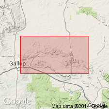
Dalton sandstone member of Mesaverde formation. Massive sandstones that laterally replace the upper part of Dilco coal member of Mesaverde formation in part of area from Gallup eastward toward Mount Taylor, northwestern New Mexico. In northern part of T. 16 N., R. 17 W. this sandstone body is 180+/- feet thick, and includes only 2 thin beds of softer sandstone and sandy shale. To east it is both split and underlain by beds of marine shale composing the western end of Mulatto tongue of Mancos shale. Where split by Mulatto tongue the upper member of Dalton sandstone is 100+/- feet thick and the lower member 72+/- feet thick. Still further east both sandstones are completely replaced by marine Mancos shale. Is of Colorado age [Late Cretaceous].
Named from excellent exposures at Dalton Pass, [in sec. 4, T. 16 N., R. 14 W., McKinley Co.], Gallup region, northwestern NM, where it supports the divide and forms a conspicuous bench in canyon draining to north.
Source: US geologic names lexicon (USGS Bull. 896, p. 568-569).
- Usage in publication:
-
- Dalton sandstone member
- Modifications:
-
- Revised
- AAPG geologic province:
-
- San Juan basin
Summary:
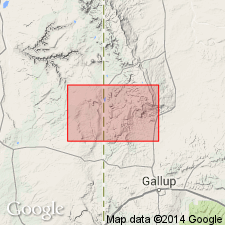
Dalton sandstone member of Mesaverde formation reassigned as middle member of Crevasse Canyon formation (new) of Mesaverde group in Tohatchi quad, McKinley Co., NM in San Juan basin. Overlies Dilco member and lower Gibson member of Crevasse Canyon. Is divisible into a lower sandstone, a 20-45 ft thick homogeneous orange-pink of coarse- to fine-grained sandstone with moderately well-sorted quartz grains, in a clay matrix, and an upper unit [thickness not given] of gray and white, massive and cross laminated sandstone that is coarse- to medium-grained, well-sorted quartz with lesser amounts of feldspar. Cementation is fair. Assigned to Late Cretaceous.
Source: GNU records (USGS DDS-6; Denver GNULEX).
- Usage in publication:
-
- Dalton sandstone member*
- Modifications:
-
- Revised
- AAPG geologic province:
-
- San Juan basin
Summary:
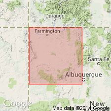
Dalton sandstone member of Mesaverde formation reassigned to Crevasse Canyon formation of Mesaverde group (rank raised). Term Mesaverde group extended throughout San Juan basin of southwest CO and northwest NM. Is the second member from base of four members of Crevasse Canyon. Overlies Dilco coal member and underlies Bartlett barren member of Crevasse Canyon. Of Late Cretaceous age. Small geologic map. Diagrammatic cross section.
Source: GNU records (USGS DDS-6; Denver GNULEX).
- Usage in publication:
-
- Dalton Sandstone Member*
- Modifications:
-
- Biostratigraphic dating
- AAPG geologic province:
-
- San Juan basin
Summary:
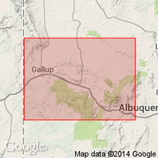
Study of palynomorphs from samples of coals and shales of the Upper Cretaceous Crevasse Canyon Formation indicate a biostratigraphic age assignment of Coniacian and Santonian for the formation. Crevasse Canyon Formation, in the Hosta Butte area, McKinley Co, NM (San Juan basin), overlies Gallup Sandstone (Turonian) and is overlain by Hosta Tongue of the Point Lookout Sandstone (Santonian). Crevasse Canyon is separated into lower and upper parts by the Mulatto Tongue (Coniacian) of the Mancos Shale; lower part comprised of Dilco Coal Member (Coniacian) and upper part comprised of Dalton Sandstone Member (Coniacian) and Gibson Coal Member (Santonian). Turonian/Coniacian Stage boundary is queried at the Gallup/Dilco contact at base of Crevasse Canyon Formation. Coniacian/Santonian Stage boundary is queried at the Dalton/Gibson contact within the upper part of the Crevasse Canyon. Samples were examined from the Dilco and Gibson Members, but not the Dalton Member. Crevasse Canyon is tentatively divided into 3 pollen zones spanning the Coniacian and Santonian. The stage assignments are derived from invertebrate zone fossils found in the associated marine rocks. The Mulatto Tongue yields lower Coniacian INOCERAMUS DEFORMIS near Tohatchi. The Hosta Tongue of the Point Lookout Sandstone yields the middle Santonian ammonite CLIOSCAPHITES VERMIFORMIS. The Gibson Coal Member lies directly below the Hosta Tongue, consequently all the Gibson in the area is probably of Santonian age. [The Coniacian age assignment for the Dalton appears to be arbitrary; it could also be Santonian, or both.]
Source: GNU records (USGS DDS-6; Denver GNULEX).
For more information, please contact Nancy Stamm, Geologic Names Committee Secretary.
Asterisk (*) indicates published by U.S. Geological Survey authors.
"No current usage" (†) implies that a name has been abandoned or has fallen into disuse. Former usage and, if known, replacement name given in parentheses ( ).
Slash (/) indicates name conflicts with nomenclatural guidelines (CSN, 1933; ACSN, 1961, 1970; NACSN, 1983, 2005, 2021). May be explained within brackets ([ ]).