The National Geologic Map Database is migrating to a new infrastructure. We apologize for any service disruptions during this process.
|
|---|


- Usage in publication:
-
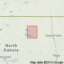
- Dahlen Formation
- Modifications:
-
- Revised
- AAPG geologic province:
-
- Williston basin
Summary:
Revised in that Dahlen Formation, top formation of Coleharbor Group in report area, overlies the newly named Churchs Ferry Formation of Coleharbor Group. Underlies Oahe Formation. Author states that Hansboro Member is excluded by him from Dahlen. Covers nearly all of Ramsey Co, ND, Williston basin. Areal extent and thickness map. May be more than 40 ft thick. Was deposited during the main late Wisconsinan ice advance.
Source: GNU records (USGS DDS-6; Denver GNULEX).
For more information, please contact Nancy Stamm, Geologic Names Committee Secretary.
Asterisk (*) indicates published by U.S. Geological Survey authors.
"No current usage" (†) implies that a name has been abandoned or has fallen into disuse. Former usage and, if known, replacement name given in parentheses ( ).
Slash (/) indicates name conflicts with nomenclatural guidelines (CSN, 1933; ACSN, 1961, 1970; NACSN, 1983, 2005, 2021). May be explained within brackets ([ ]).