The National Geologic Map Database is migrating to a new infrastructure. We apologize for any service disruptions during this process.
|
|---|


- Usage in publication:
-
- Curry clay [member]
- Modifications:
-
- Principal reference
- Dominant lithology:
-
- Clay
- AAPG geologic province:
-
- Bend arch
Summary:
Pg. 17-21, pl. 3; F.B. Plummer IN Cheney, M.G., 1948, Abilene Geol. Soc. [Gdbk.] Spring Field Trip, June 11-12, p. 8 (road log). Curry clay [member of Harpersville formation]. Purplish red and greenish red, grading in places into deep maroon. Thickness varies from a few feet to 32 feet depending upon thickness of sand in section above it. Occurs between upper and lower Crystal Falls limestone layers, just above Quinn clay in areas where thick sandstone deposits of Parks Mountain and its probable equivalent, Cisco Lake sandstone, do not occur. [Age is Pennsylvanian (Cisco).]
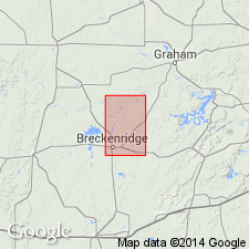
Named from Curry Farm, 5 mi south and 2.25 mi west of Breckenridge, Stephens Co. central northern TX (Plummer, 1948; Plummer and Bradley, 1949). [The Curry family were pioneers of Stephens County.]
Source: US geologic names lexicon (USGS Bull. 1200, p. 1012).
- Usage in publication:
-
- Curry clay member
- Modifications:
-
- Revised
- Dominant lithology:
-
- Clay
- AAPG geologic province:
-
- Bend arch
For more information, please contact Nancy Stamm, Geologic Names Committee Secretary.
Asterisk (*) indicates published by U.S. Geological Survey authors.
"No current usage" (†) implies that a name has been abandoned or has fallen into disuse. Former usage and, if known, replacement name given in parentheses ( ).
Slash (/) indicates name conflicts with nomenclatural guidelines (CSN, 1933; ACSN, 1961, 1970; NACSN, 1983, 2005, 2021). May be explained within brackets ([ ]).