

- Usage in publication:
-
- Cuero formation
- Modifications:
-
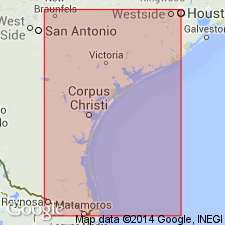
- Areal extent
- AAPG geologic province:
-
- Gulf Coast basin
Summary:
Pg. 20 [meeting program; Pg. 932 in bulletin]. Name appears on a chart [as formation of Fleming group]; occurs below Lapara member of Goliad formation and above Oakville formation. [Age is Miocene.]
…"paper presents (1) a description of the deposits of the Coastal Plain between Brazos River and Rio Grande beginning with Catahoula and extending upwards through Recent, (2) a correlation of the up-dip terrace deposits with equivalent formations of the Gulf Coastal Plain, (3) a discussion of the age of these terrace dposits, (4) an outline of certain fault zones that are involved in the geologic history of the Coastal Plain deposits, and (5) a geologic history of sedimentation during the late Cenozoic time."…
Source: US geologic names lexicon (USGS Bull. 1200, p. 1003); Publication.
- Usage in publication:
-
- Cuero formation
- Modifications:
-
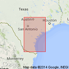
- Principal reference
- Dominant lithology:
-
- Clay
- Sandstone
- AAPG geologic province:
-
- Gulf Coast basin
Summary:
Pg. 1724-1726. Cuero formation (in Fleming group). Proposed for the predominantly red, pink, green, and gray section of clays and sandstones lying above the Oakville formation and below the Goliad formation. Thickness about 350 feet. In Bee, Karnes, and DeWitt Counties, formation is identical with the section assigned to the Lower Lagarto by Weeks (1933, AAPG Bull., v. 17, no. 5) and is part of section assigned to Lagarto (emended) by Plummer and others (Univ. Texas Bull. 3232, 1933). Recognized in southern Texas. Age is late Miocene.
Name taken from a city in DeWitt Co., southern TX.
Source: US geologic names lexicon (USGS Bull. 1200, p. 1003-1004).
For more information, please contact Nancy Stamm, Geologic Names Committee Secretary.
Asterisk (*) indicates published by U.S. Geological Survey authors.
"No current usage" (†) implies that a name has been abandoned or has fallen into disuse. Former usage and, if known, replacement name given in parentheses ( ).
Slash (/) indicates name conflicts with nomenclatural guidelines (CSN, 1933; ACSN, 1961, 1970; NACSN, 1983, 2005, 2021). May be explained within brackets ([ ]).