The National Geologic Map Database is migrating to a new infrastructure. We apologize for any service disruptions during this process.
|
|---|


- Usage in publication:
-
- Cuchillo Formation
- Modifications:
-
- Contact revised
- AAPG geologic province:
-
- Orogrande basin
Summary:
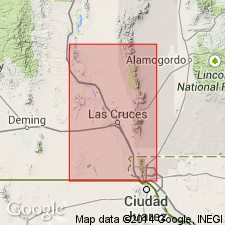
Revised--upper contact changed. Underlies the Benigno Limestone (first used) on the southeast edge of La Mesa in Sierra de Juarez, Dona Ana Co, NM in Orogrande basin. Overlies Las Vigas Formation. La Mesa is part of the Mesilla Bolson, bounded on the west by the East Potrillo Mountains, West Potrillo Mountains, Aden Hills, Sleeping Lady Hills, and Cedar Hills, and on the east by the Robledo Mountains (at the north tip of La Mesa) and the Rio Grande Valley. Is of Cretaceous age.
Source: GNU records (USGS DDS-6; Denver GNULEX).
For more information, please contact Nancy Stamm, Geologic Names Committee Secretary.
Asterisk (*) indicates published by U.S. Geological Survey authors.
"No current usage" (†) implies that a name has been abandoned or has fallen into disuse. Former usage and, if known, replacement name given in parentheses ( ).
Slash (/) indicates name conflicts with nomenclatural guidelines (CSN, 1933; ACSN, 1961, 1970; NACSN, 1983, 2005, 2021). May be explained within brackets ([ ]).