The National Geologic Map Database is migrating to a new infrastructure. We apologize for any service disruptions during this process.
|
|---|


- Usage in publication:
-
- Cuchara formation*
- Modifications:
-
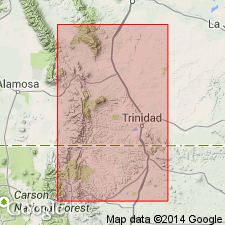
- Areal extent
- AAPG geologic province:
-
- Las Vegas-Raton basin
Summary:
Crops out in trough of Raton basin part of the Las Vegas-Raton basin south of Spanish Peaks and extends to northern part of Huerfano Park. Is at least 5,000 ft thick in the center of the basin. Is a massive red, pink, and white sandstone which may be conglomeratic and well-consolidated, interbedded with red, gray, and tan claystone and red shale with lenses of green shale. Was a piedmont and floodplain deposit probably derived from underlying Poison Canyon Formation.
Source: GNU records (USGS DDS-6; Denver GNULEX).
- Usage in publication:
-
- Cuchara Formation*
- Modifications:
-
- Overview
- AAPG geologic province:
-
- Las Vegas-Raton basin
Summary:
Consists largely of yellowish-gray conglomerate, sandstone, and mudstone derived from both sedimentary and crystalline rocks, an intimate mixture of Huerfano and Farisita lithologies. Abandonment of name suggested [but not formally stated]. Mapped with Huerfano and Farisita in Huerfano Park, in Huerfano Co, CO in the Las Vegas-Raton basin. Assigned an Eocene age.
Source: GNU records (USGS DDS-6; Denver GNULEX).
For more information, please contact Nancy Stamm, Geologic Names Committee Secretary.
Asterisk (*) indicates published by U.S. Geological Survey authors.
"No current usage" (†) implies that a name has been abandoned or has fallen into disuse. Former usage and, if known, replacement name given in parentheses ( ).
Slash (/) indicates name conflicts with nomenclatural guidelines (CSN, 1933; ACSN, 1961, 1970; NACSN, 1983, 2005, 2021). May be explained within brackets ([ ]).