

- Usage in publication:
-
- Crouse limestone*
- Modifications:
-
- Original reference
- Dominant lithology:
-
- Limestone
- AAPG geologic province:
-
- Chautauqua platform
Summary:
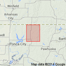
Pg. 21, 22. Crouse limestone. A prominent limestone, 3+/- feet thick, which lies 70+/- feet below Wreford limestone and 50 feet above Cottonwood limestone in Foraker quadrangle, Osage County, central northern Oklahoma. Characteristic features are form of outcrop, which shows many large massive blocks; absence of recognizable fossils in any abundance, with exception of small FUSULINA, which are plentiful; and presence of many smooth round holes, which are vertical or steeply inclined to the bedding. Age is Permian.
Named from Crouse Hill, Foraker quadrangle, Osage Co., central northern OK.
Source: US geologic names lexicon (USGS Bull. 896, p. 548).

- Usage in publication:
-
- Crouse limestone member*
- Modifications:
-
- Overview
Summary:
Crouse limestone member of Garrison shale adopted by the USGS in 1916. Recognized in Osage County, central northern Oklahoma. Age is Permian.
Source: US geologic names lexicon (USGS Bull. 896, p. 549); GNC index card files (USGS-Reston).

- Usage in publication:
-
- Crouse limestone member
- Modifications:
-
- Revised
- Areal extent
- AAPG geologic province:
-
- Forest City basin
Summary:
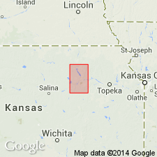
Pg. 7. Crouse limestone member of Bigelow limestone formation of Council Grove group. Used this name in southeastern Nebraska. Consists of two limestones separated by olive colored shales. Thickness 11+ feet. Overlies Easly Creek shale formation of Council Grove group. Underlies Blue Rapids shale member of Bigelow. Age is Permian (Big Blue).
[See also entry under Bigelow limestone formation and Condra and Upp (1931) entry under Sabetha.]
Source: Publication; US geologic names lexicon (USGS Bull. 896, p. 549, Bigelow entry p. 183); GNC KS-NE Permian Corr. Chart, Oct. 1936.
- Usage in publication:
-
- Crouse limestone
- Modifications:
-
- Revised
- AAPG geologic province:
-
- Forest City basin
Summary:
Pg. 64-65. Condra (1935) employed term Bigelow limestone as comprising (ascending) Sabetha limestone (Crouse limestone), Blue Rapids shale, and Funston limestone. The Bigelow thus included strata between the Easly Creek shale and Speiser shale. To be consistent with classification applied to strata above and below them, these beds should be divided into formations. Proposed that Bigelow be dropped as stratigraphic term and that Crouse limestone, Blue Rapids shale, and Funston limestone be recognized as formations. In Council Grove group. Age is Permian (Wolfcamp).
Source: US geologic names lexicon (USGS Bull. 1200, p. 992).
- Usage in publication:
-
- Crouse Limestone
- Modifications:
-
- Overview
Summary:
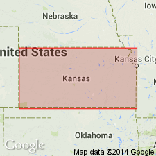
(Paleozoic Era; Permian System by H.G. O'Connor, D.E. Zeller, C.K. Bayne, J.M Jewett, and Ada Swineford, p. 47.) Crouse Limestone of Council Grove Group. In Kansas consists of an upper and a lower limestone separated by a few feet of fossiliferous shale. The upper part displays platy structure and weathers tan to brown. The limestone beds locally are cherty. Thickness about 6 to 18 feet. Occurs above Easly Creek Shale and below Blue Rapids Shale, both of Council Grove Group. Age is Early Permian; Gearyan Provincial Stage (of H.G. O'Connor, 1963, AAPG Bull., v. 47, p. 1873-1877).
Source: Publication.
For more information, please contact Nancy Stamm, Geologic Names Committee Secretary.
Asterisk (*) indicates published by U.S. Geological Survey authors.
"No current usage" (†) implies that a name has been abandoned or has fallen into disuse. Former usage and, if known, replacement name given in parentheses ( ).
Slash (/) indicates name conflicts with nomenclatural guidelines (CSN, 1933; ACSN, 1961, 1970; NACSN, 1983, 2005, 2021). May be explained within brackets ([ ]).