

- Usage in publication:
-
- Creola member
- Modifications:
-
- Original reference
- Dominant lithology:
-
- Glauconite
- Limestone
- AAPG geologic province:
-
- Gulf Coast basin
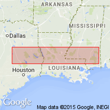
Summary:
Pg. 879 (fig. 133), 881 [1940]. Creola member of Yegua formation. Name applied to beds of upper Yegua which contain unmistakable marine indicators, such as marine fossils, glauconite, limestone layers, or fucoids. This part of the Yegua has been referred to as a "transition zone" between the typical Yegua and typical Jackson. Thickness varies from 10 feet at Garland's Creek, Clarke County, eastern Mississippi, to 40 feet at Pineland, eastern Texas.; at type locality 32.4 feet. Bounded at top by a widespread clear-cut sharp disconformity on which the lower Jackson rests; at base, grades into typical nonmarine Yegua beds; west of Pineland, Creola outcrops become more and more nonmarine and fade into uppermost Yegua beds. Age is Eocene (Claiborne).
Type locality: Creola Bluff on the Red River, near Montgomery, Grand Parish, central LA. [Old town of Creola was built on the bluff in 1850].
Source: US geologic names lexicon (USGS Bull. 1200, p. 979).
- Usage in publication:
-
- Creola Member
- Modifications:
-
- Areal extent
- Dominant lithology:
-
- Sand
- AAPG geologic province:
-
- Mid-Gulf Coast basin
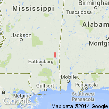
Summary:
Creola Member of Cockfield Formation described in the #1 Ketler core, at Hiwannee on the Chickasawhay River, Wayne Co., southeastern MS. Unit occupies interval between 215.7 ft and 230 ft and consists of brownish gray to brownish black, moderately to sparsely fossiliferous sand. Upper contact with Moodys Branch Formation is sharp; lower contact with undifferentiated Cockfield Formation is gradational. Unit is not present in the #1 Young core at Waynesboro where the Moodys Branch is thicker. Updip facies of the Creola might be equivalent to the lower Moodys Branch Formation downdip.
Source: GNU records (USGS DDS-6; Reston GNULEX).
- Usage in publication:
-
- Creola Member
- Modifications:
-
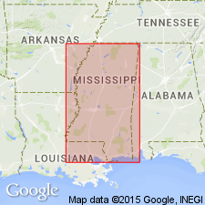
- Overview
- AAPG geologic province:
-
- Mid-Gulf Coast basin
Summary:
Creola Member of Cockfield Formation. Top of Claiborne Group. Age is middle Eocene (Bartonian); nannofossil zone NP17, planktic foram zone P14 (T. ROHRI zone).
Source: Publication.
For more information, please contact Nancy Stamm, Geologic Names Committee Secretary.
Asterisk (*) indicates published by U.S. Geological Survey authors.
"No current usage" (†) implies that a name has been abandoned or has fallen into disuse. Former usage and, if known, replacement name given in parentheses ( ).
Slash (/) indicates name conflicts with nomenclatural guidelines (CSN, 1933; ACSN, 1961, 1970; NACSN, 1983, 2005, 2021). May be explained within brackets ([ ]).