The National Geologic Map Database is migrating to a new infrastructure. We apologize for any service disruptions during this process.
|
|---|


- Usage in publication:
-
- Coyote Creek Member
- Modifications:
-
- Named
- Dominant lithology:
-
- Sandstone
- Shale
- AAPG geologic province:
-
- Powder River basin
- Williston basin
Summary:
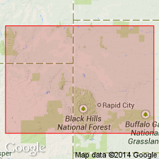
Named as the upper member of the Fall River Formation of the Inyan Kara Group for the Coyote Creek oil field. Type well is the Mobil Producing Co. No. F-43-33-G in NE 1/4, SE 1/4 sec 33, T49N, R58W, Crook Co, WY in the Powder River basin. Extends into northeast MT and western SD part of the Williston basin. This report is a study of subsurface data over the entire report area and of surface data collected from outcrops around the Black Hills. Overlies the newly named Morton Member of the Fall River. This contact is conformable in WY and disconformable in SD and MT. Underlies Thermopolis Shale, a sharp conformable contact. Member lies between 6,475 and 6,505 in the type well. Ranges between 0 (southeast MT) and 80 (western SD) ft thick. Consists of buff to gray, fine- to very fine-grained, moderately well sorted sandstone with subangular grains, dark shale partings, and some carbonaceous material in type well. Facies change from sandstone to shale occurs in Black Hills area. Younger beds present to east. Member records a major southeast shift of depocenters. Divisible into shallow marine and deltaic to marginal marine to nonmarine facies. Twigs, leaves, plant remains commonly pyritized present in deltaic deposits. Early Cretaceous age. E-logs. Cross sections. Isopach map.
Source: GNU records (USGS DDS-6; Denver GNULEX).
For more information, please contact Nancy Stamm, Geologic Names Committee Secretary.
Asterisk (*) indicates published by U.S. Geological Survey authors.
"No current usage" (†) implies that a name has been abandoned or has fallen into disuse. Former usage and, if known, replacement name given in parentheses ( ).
Slash (/) indicates name conflicts with nomenclatural guidelines (CSN, 1933; ACSN, 1961, 1970; NACSN, 1983, 2005, 2021). May be explained within brackets ([ ]).