

- Usage in publication:
-
- Couch formation
- Modifications:
-
- Original reference
- AAPG geologic province:
-
- Permian basin
Summary:
Pg. 4 (table 1), 5-6. Couch formation. Compact well-sorted calcareous sand and gravel; typically pinkish gray. Thickness at type locality 125 feet; thickness varies markedly with relief of underlying bedrock; maximum development in deeper pre-Cenozoic valleys; thins and wedges out against higher ridges and divides on bedrock surface. Underlies Bridwell formation (new); unconformably overlies Triassic and Cretaceous rocks. [Age is early Pliocene.]
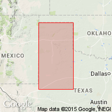
Type locality: about 7 mi east of Crosbyton, Crosby Co., western TX. Named from Couch Ranch in Blanco Canyon. Extends northward into Texas panhandle.
Source: US geologic names lexicon (USGS Bull. 1200, p. 956-957).
- Usage in publication:
-
- Couch formation
- Modifications:
-
- Areal extent
Van Siclen, D.C., 1957, Cenozoic strata on the southwestern Osage Plains of Texas: Journal of Geology, v. 65, no. 1, p. 47-60.
Summary:
Pg. 49 (fig. 2), 51, 52. Couch formation. Silt and fine sand, calcareous, characteristically pinkish-buff, basal gravel of limestone and siliceous pebbles. Thickness 200 feet. Underlies Bridwell formation; unconformably overlies 10 feet of unnamed Oligocene or Miocene quartzite conglomerate. Stratigraphic section (fig. 2) lists formation under heading Pliocene (and Miocene?).
Source: Publication; US geologic names lexicon (USGS Bull. 1200, p. 956-957).
For more information, please contact Nancy Stamm, Geologic Names Committee Secretary.
Asterisk (*) indicates published by U.S. Geological Survey authors.
"No current usage" (†) implies that a name has been abandoned or has fallen into disuse. Former usage and, if known, replacement name given in parentheses ( ).
Slash (/) indicates name conflicts with nomenclatural guidelines (CSN, 1933; ACSN, 1961, 1970; NACSN, 1983, 2005, 2021). May be explained within brackets ([ ]).