The National Geologic Map Database is migrating to a new infrastructure. We apologize for any service disruptions during this process.
|
|---|


- Usage in publication:
-
- Cosumnes formation
- Modifications:
-
- Named
- Dominant lithology:
-
- Sandstone
- Conglomerate
- Tuff
- AAPG geologic province:
-
- Sierra Nevada province
Summary:
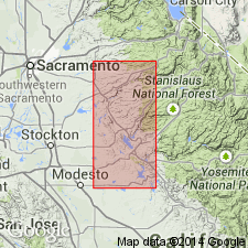
Named for exposures along Cosumnes River, CA. Type locality: N type section of Amador group on Cosumnes River, El Dorado and Amador Cos., CA where is basal fm of group. Consists of alternated SS and CGL 1200 feet thick; these pass upward into sheared arkosic SS and dark clay-slate which in turn grade upward into thin-bedded tuffs and fine sediments; basic flows and red and green cherts locally present in upper part. Thickness 4400 feet E of Calaveras anticline; thicker W of anticline due to rhyolite flows and agglomerates. Underlies Logtown Ridge agglomerates (new); unconformably overlies Calaveras (Clipper Gap fm). Age believed to be late Middle to early Late Jurassic.
Source: GNU records (USGS DDS-6; Menlo GNULEX).
- Usage in publication:
-
- Cosumnes formation*
- Modifications:
-
- Biostratigraphic dating
- Areal extent
- AAPG geologic province:
-
- Sierra Nevada province
Summary:
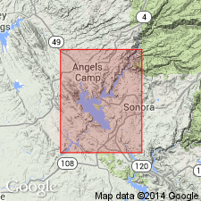
Mapped in Angels Camp and Sonora 7.5' quads. Generalized section is 5100 feet. thick. Ammonite was found in thin-bedded tuff about 2000 feet W of contact between Cosumnes fm and overlying Logtown Ridge formation on N bank of Cosumnes River about 2 mi below Huse Bridge and about 1850 feet E of W boundary of Fiddletown quad. Imlay (pers. commun., 1/17/50) states that fossil is perisphinctid ammonite which first appeared in Middle Jurassic but is more common in early Upper Jurassic than in older beds. Age is Middle or Late Jurassic.
Source: GNU records (USGS DDS-6; Menlo GNULEX).
- Usage in publication:
-
- Cosumnes formation*
- Modifications:
-
- Biostratigraphic dating
- AAPG geologic province:
-
- Sierra Nevada province
Summary:
Upper part of Cosumnes Formation at type is of Callovian (Late Jurassic) age based on ammonites. [Therefore age of Cosumnes is Middle(?) and Late Jurassic.]
Source: GNU records (USGS DDS-6; Menlo GNULEX).
- Usage in publication:
-
- Cosumnes formation*
- Modifications:
-
- Areal extent
- AAPG geologic province:
-
- Sierra Nevada province
Summary:
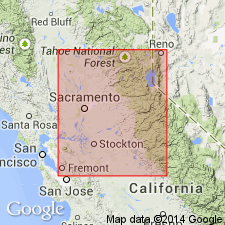
Pg. 17-18, pls. 1-11 (see also L.D. Clark and others, 1963, San Andreas quadrangle, USGS Geol. Quad. Map GQ-222). Cosumnes formation. Type section extends from top of slate layer on north side of Cosumnes River, about 7,400 feet southwest of Huse Bridge on Highway 49, southwestward to about 2.1 miles southwest of Huse Bridge. Exposures extend south beyond Sutter Creek and probably extend north beyond south part of El Dorado County (as shown on map). Most abundant rock is black-gray slate and siltstone with some conglomerate and graywacke. Age is in part Callovian based on ammonite (Imlay, 1961, USGS Prof. Paper 374-D; [and R.W. Imlay, written commun., 1959 (USGS Preliminary Report on Referred Fossils MD-59-14, May 20, 1959)]. [In this report, Callovian included in Late Jurassic.]
[Author does not capitalize rank terms; however, units are considered formal.]
Source: Publication; GNU records (USGS DDS-6; Menlo GNULEX).
- Usage in publication:
-
- Cosumnes Formation
- Modifications:
-
- Revised
- Age modified
- AAPG geologic province:
-
- Sierra Nevada province
Summary:
Cosumnes Formation removed from Amador Group, name herein abandoned. Contact of type Cosumnes with overlying Logtown Ridge Formation lowered 2000 ft at expense of the Cosumnes to a regional bedding plane fault, thereby removing fossil locality in upper part of Cosumnes. Cosumnes grouped with underlying tectonic-stratigraphic sequence of rocks called "the western belt" of Calaveras Formation (Clark, 1964). Cosumnes as here restricted is Late Jurassic or older in age.
Source: GNU records (USGS DDS-6; Menlo GNULEX).
- Usage in publication:
-
- Cosumnes Formation†
- Modifications:
-
- Abandoned
- AAPG geologic province:
-
- Sierra Nevada province
Summary:
Most rocks of restricted Cosumnes Formation of Sharp and Duffield (1973) form scattered, fault-bounded blocks in melange; therefore name Cosumnes Formation is herein abandoned. Because melange is tectonostratigraphic unit of type described by Hsu (1968), essentially all rocks that compose the melange are unknown in age. Rocks formerly part of Cosumnes Formation are informally referred to as rocks of "Cosumnes affinities".
Source: GNU records (USGS DDS-6; Menlo GNULEX).
For more information, please contact Nancy Stamm, Geologic Names Committee Secretary.
Asterisk (*) indicates published by U.S. Geological Survey authors.
"No current usage" (†) implies that a name has been abandoned or has fallen into disuse. Former usage and, if known, replacement name given in parentheses ( ).
Slash (/) indicates name conflicts with nomenclatural guidelines (CSN, 1933; ACSN, 1961, 1970; NACSN, 1983, 2005, 2021). May be explained within brackets ([ ]).