The National Geologic Map Database is migrating to a new infrastructure. We apologize for any service disruptions during this process.
|
|---|


- Usage in publication:
-
- Cordito member
- Modifications:
-
- Original reference
- Dominant lithology:
-
- Tuff
- Arkose
- Siltstone
- Graywacke
- AAPG geologic province:
-
- San Juan basin
Summary:
Pg. 38, 48-50, pl. 1. Cordito Member of Los Pinos Formation. Rhyolite-fragment conglomerate, tuff, and sandstone with minor rhyolite flows. Maximum thickness about 600 feet. Unconformably underlies Cisneros (new) and Dorado (new) basalts; disconformably overlies Jarita basalt (new) and Biscara (new) and Biscara-Esquibel (new) members of Los Pinos formation. Name credited to Butler (unpub. dissert.). Age is Pliocene.
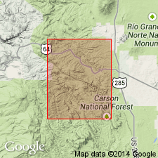
Named from exposures in Canyon de Cordito[?], 4 mi south of Tres Piedras, Las Tablas quadrangle, Rio Arriba Co., central northern NM.
[Canon de Tio Gordito is 4 mi south of Tres Piedras, in secs. 9, 10, 11, T. 27 N., R. 9 E., Petaca Peak 7.5-min quadrangle, Rio Arriba Co., Carson National Forest area, central northern NM (USGS GNIS database, USGS historical topographic map collection TopoView; accessed June 8, 2014).]
Source: US geologic names lexicon (USGS Bull. 1200, p. 940-941).
- Usage in publication:
-
- Cordito Member*
- Modifications:
-
- Overview
- AAPG geologic province:
-
- San Juan basin
Summary:
Assigned as the upper member of the Los Pinos Formation. Extends along Tusas Mountains, Rio Arriba Co, NM, San Juan basin. Thickness varies from 0-120 m. Absence in north due to nondeposition. Absence in west due to removal by erosion. Overlies Precambrian rocks, Conejos? Formation, El Rito Formation, Esquibel Member (adopted) of Los Pinos. Is overlain by flows of Servilleta Formation. Underlies and interfingers with Santa Fe Group. Composed of coarse, volcaniclastic sandstone to boulder conglomerate containing some mudflow deposits. Sandstone is light brown, moderately well sorted and bedded, and poorly cemented. Conglomerate is poorly sorted, locally crudely laminated to cross-bedded, and cemented with silica. The clasts are angular to well rounded, consist of intermediate- and felsic composition volcanic rocks, Precambrian schist, quartzite, and rhyolite. Boulders can be as long as 4.5 m. Mudflow deposits include unsorted gravel and sand, and some are completely angular clasts of gray rhyolite. The rhyolite breccia might represent a volcanic flow breccia from local vents. Is of Miocene and Oligocene age. Overlies a tuff dated as 25.9 m.y.
Source: GNU records (USGS DDS-6; Denver GNULEX).
For more information, please contact Nancy Stamm, Geologic Names Committee Secretary.
Asterisk (*) indicates published by U.S. Geological Survey authors.
"No current usage" (†) implies that a name has been abandoned or has fallen into disuse. Former usage and, if known, replacement name given in parentheses ( ).
Slash (/) indicates name conflicts with nomenclatural guidelines (CSN, 1933; ACSN, 1961, 1970; NACSN, 1983, 2005, 2021). May be explained within brackets ([ ]).