

- Usage in publication:
-
- Copperopolis Latite*
- Modifications:
-
- Named
- Dominant lithology:
-
- Latite
- AAPG geologic province:
-
- Great Basin province
- Wasatch uplift
Summary:
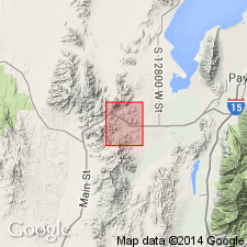
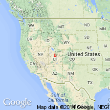
Named as lowermost of three formations of Tintic Mountain Volcanic Group. Type locality is in Copperopolis Canyon in west-central part of East Tintic Mountains, 10 mi southwest of East Tintic district, secs 31-33, T11S, R2W, Juab and Utah Cos, UT in Great Basin province and on Wasatch uplift. In this area unit consists of: 1) a basal member, dark-green, moderately coarse grained, massive agglomerate and spatter breccia; 2) a tuff member, fine- to medium-grained, gray-green air-fall tuff, which disconformably overlies basal member; and 3) a flow member (top), greenish-gray, black, or reddish-brown fine-grained vitrophyre and fine-grained porphyry. Some flows in southernmost part of district characterized by slaggy upper surface or my amygdules. All three members are of irregular thickness, but locally each are several hundred ft or more thick. Only member of Copperopolis to crop out in East Tintic district is the fine-grained flow member, which is conspicuously exposed in sec 26, T10S, R2W. Overlies Packard Quartz Latite unconformably and is cut by monzonite of Silver City stock. Latter two units dated isotopically as 32.8 +/-1.0 and 31.5 +/-0.9 m.y., thus age of Copperopolis is middle Oligocene. Underlies Latite Ridge Latite (new) of Tintic Mountain Volcanic Group (both new). Probably erupted from one or more vents near Volcano Ridge in cycles separated by volcanic quiescence. Geologic map, sections, stratigraphic chart.
Source: GNU records (USGS DDS-6; Denver GNULEX).
- Usage in publication:
-
- Copperopolis Latite*
- Modifications:
-
- Not used
Summary:
Not used in the Juab-Sevier Valley areas, UT in the Great Basin province. Rocks assigned to Copperopolis by Meibos (1983) assigned to a middle part of the upper unit chiefly of ash-flow and welded tuffs of Goldens Ranch Formation (adopted).
Source: GNU records (USGS DDS-6; Denver GNULEX).
For more information, please contact Nancy Stamm, Geologic Names Committee Secretary.
Asterisk (*) indicates published by U.S. Geological Survey authors.
"No current usage" (†) implies that a name has been abandoned or has fallen into disuse. Former usage and, if known, replacement name given in parentheses ( ).
Slash (/) indicates name conflicts with nomenclatural guidelines (CSN, 1933; ACSN, 1961, 1970; NACSN, 1983, 2005, 2021). May be explained within brackets ([ ]).