The National Geologic Map Database is migrating to a new infrastructure. We apologize for any service disruptions during this process.
|
|---|


- Usage in publication:
-
- Copan member
- Modifications:
-
- Named
- Dominant lithology:
-
- Sandstone
- Shale
- Limestone
- AAPG geologic province:
-
- Chautauqua platform
Summary:
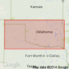
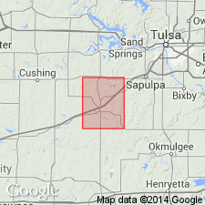
Named as middle member (of 3) of Wann formation of Sapulpa group; named for the town of Copan, Washington Co, OK on the Chautauqua platform. No type locality designated. Outcrops near the KS State line over an area about 12 mi wide; occupies practically all the region around Dewey, Bartlesville, Ochelata, and Ramona, OK. Consists, in the vicinity of Wann, of considerable thicknesses of fine-grained, massive sandstones in the lower part. Middle part is largely shale which is well exposed on slopes of hills north and west of Wann. A bed of coal about 14 inches thick is seen 3 mi southeast of Wann. Massive sandstones prominent along Cotton Creek and along the 96th meridian south of Bartlesville. Most prominent stratigraphic feature is certain limestone lentils which are Dewey limestone lentil (new, lower) and Avant limestone lentil (new, upper). Thickness of Copan member is 250 ft near Wann. Overlies Hogshooter limestone member (new) and underlies Stanton limestone member, both of the Wann formation of Sapulpa group. Stratigraphic chart. Pennsylvanian age.
Source: GNU records (USGS DDS-6; Denver GNULEX).
- Usage in publication:
-
- Copan formation
- Modifications:
-
- Revised
- AAPG geologic province:
-
- Chautauqua platform
Summary:
Pg. 13, 16. Copan formation (restricted). The Copan as defined by Ohern in 1910 included all beds between base of Stanton limestone above and top of Hogshooter limestone below. The Stanton limestone thins out a few miles south of Kansas line, and the next logical formation boundary is base of Tiger Creek sandstone, which persists from Nowata quadrangle through Bristow quadrangle. The adoption of that boundary line, however, throws into Bristow formation some rocks included in Copan formation as originally defined by Ohern, but this slight restriction of Copan is believed to be justified, as it will make the Copan a map unit over a large area and prevent the introduction of a new name for rocks = major part of Ohern's Copan. The Hogshooter limestone is thought by writer to be same as "Layton lime" of Bristow quadrangle. Thickness of Copan formation in Bristow quadrangle 600 to 700 feet; divided into (descending): (1) upper shale, 150 feet; (2) upper sandstone and interbedded shale, including a lenticular limestone and Dewey limestone member, 85 to 250 feet; (3) middle shale 100 to 125 feet; (4) lower sandstone with interbedded shale, 100 to 150 feet; (5) lower shale, 100 to 200 feet.
Source: US geologic names lexicon (USGS Bull. 896, p. 516).

- Usage in publication:
-
- Copan formation
- Modifications:
-
- Overview
- AAPG geologic province:
-
- Chautauqua platform
Summary:
Pg. 76. Copan formation. Named by D.W. Ohern, 1910. Consists of sandstone and gray shale, and in its upper part includes Dewey [Avant] limestone member. Thickness 600 to 700 feet. Includes lower part of Ochelata formation, the underlying Dewey limestone, and the Nellie Bly formation. Named for Copan, Washington County, Oklahoma.
Source: US geologic names lexicon (USGS Bull. 896, p. 516).
For more information, please contact Nancy Stamm, Geologic Names Committee Secretary.
Asterisk (*) indicates published by U.S. Geological Survey authors.
"No current usage" (†) implies that a name has been abandoned or has fallen into disuse. Former usage and, if known, replacement name given in parentheses ( ).
Slash (/) indicates name conflicts with nomenclatural guidelines (CSN, 1933; ACSN, 1961, 1970; NACSN, 1983, 2005, 2021). May be explained within brackets ([ ]).