

- Usage in publication:
-
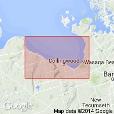
- Collingwood formation
- Modifications:
-
- Original reference
- Dominant lithology:
-
- Limestone
- Shale
- AAPG geologic province:
-
- [Appalachian basin]
Summary:
Pg. 354. Lower Utica (Collingwood formation). A thin formation of layers of fine-grained rather pure blue limestone alternating with thick beds of soft brown shale. Thickness not shown but appears to be less than 50 feet. Fauna, which is well developed at Collingwood, Ontario, Canada, differs from that of typical Utica in many respects. Overlain by darker shales containing typical Utica fauna, and underlain by Trenton limestone. [Age is Middle Ordovician.]
Source: US geologic names lexicon (USGS Bull. 896, p. 490).
- Usage in publication:
-
- Collingwood formation
- Modifications:
-
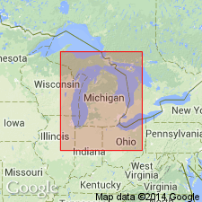
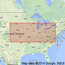
- Areal extent
- AAPG geologic province:
-
- Michigan basin
Summary:
Geographically extended the Collingwood formation into Michigan and assigned it to the upper part of the Utica group.
Source: GNU records (USGS DDS-6; Reston GNULEX).
- Usage in publication:
-
- Collingwood
- Modifications:
-
- Not used
Summary:
The Eastview and Billings formation of Ottawa-St. Lawrence Lowland represent continuous sequence of beds that together make up the former Collingwood and Gloucester formations. They are defined by lithology, the Eastview being limestone interbedded with shale and the Billings all shale.
Source: GNU records (USGS DDS-6; Reston GNULEX).
- Usage in publication:
-
- Collingwood formation*
- Modifications:
-
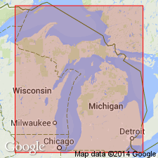
- Areal extent
- Revised
- Age modified
- AAPG geologic province:
-
- Michigan basin
Summary:
In subsurface of eastern MI, Late Ordovician rocks are 750 ft thick and are divided into Utica, Lorraine, and Queenston shales. Dark-gray to black Utica is 150 to 200 ft thick; it thins northward and, in Northern Peninsula, Bruce Peninsula, and on Manitoulin Island and adjacent islands, it is represented by Collingwood formation. Collingwood is identified in one well from Door Co., easternmost WI, but could not be identified further south. In southwestern Ontario, beds of Late Ordovician age crop out locally on Manitoulin Island and adjacent islands, along shore of Georgian Bay, and southeastward in Ontario where they are divided into (ascending) Collingwood, Gloucester, Dundas, Meaford, and Queenston formations. Collingwood, 30 to 40 ft thick, was formerly assigned to Utica because of lithologic similarity to Utica in NY. According to Sproule (1936), Collingwood rests on Trenton limestone. At north edge of Sheguindah, Manitoulin Island, Ontario, Collingwood rests on Precambrian rocks. Overlying Collingwood are dark-brown to black shales referred to as Gloucester formation by earlier workers. Canada Geological Survey includes both Collingwood and Gloucester in Billings formation, which is 100 to 270 ft thick in southwestern Ontario. Kay (1937) correlates Collingwood and Gloucester with Trenton of NY. Age of Collingwood changed from Middle Ordovician to Late Ordovician.
Source: GNU records (USGS DDS-6; Reston GNULEX).
- Usage in publication:
-
- Collingwood shale
- Modifications:
-
- Areal extent
- AAPG geologic province:
-
- Michigan basin
Summary:
Chart 2 (column 46). Collingwood shale. Shown on correlation chart in Northern Peninsula of Michigan. Occurs above Stewartville limestone. Age is Middle Ordovician (Trentonian).
Source: Publication; US geologic names lexicon (USGS Bull. 1200, p. 885-886).
- Usage in publication:
-
- Collingwood Member
- Modifications:
-
- Revised
- AAPG geologic province:
-
- Michigan basin
Summary:
Revised the Collingwood to the Collingwood Member of the Bill's Creek Shale in MI. Unit is of Late Ordovician (Cincinnatian) age.
Source: GNU records (USGS DDS-6; Reston GNULEX).
- Usage in publication:
-
- Collingwood Member
- Modifications:
-
- Revised
- AAPG geologic province:
-
- Michigan basin
Summary:
Revised the Collingwood to the Collingwood Member of the Utica Shale in the subsurface of Michigan.
Source: GNU records (USGS DDS-6; Reston GNULEX).
For more information, please contact Nancy Stamm, Geologic Names Committee Secretary.
Asterisk (*) indicates published by U.S. Geological Survey authors.
"No current usage" (†) implies that a name has been abandoned or has fallen into disuse. Former usage and, if known, replacement name given in parentheses ( ).
Slash (/) indicates name conflicts with nomenclatural guidelines (CSN, 1933; ACSN, 1961, 1970; NACSN, 1983, 2005, 2021). May be explained within brackets ([ ]).