The National Geologic Map Database is migrating to a new infrastructure. We apologize for any service disruptions during this process.
|
|---|


- Usage in publication:
-
- Coldwater shale*
- Modifications:
-
- Named
- Dominant lithology:
-
- Shale
- AAPG geologic province:
-
- Michigan basin
Summary:
Named for Coldwater River, Branch and Hillsdale Cos., southern MI. Consists of bluish, fine-grained micaceous shales. Thickness is 896 ft. Underlies Lower Marshall and overlies Berea black shale. [Age is Mississippian.]
Source: GNU records (USGS DDS-6; Reston GNULEX).
- Usage in publication:
-
- Coldwater Shale
- Modifications:
-
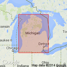
- Overview
- Areal extent
- AAPG geologic province:
-
- Michigan basin
Summary:
Although the Coldwater has the largest outcrop area of any Mississippian formation, it is inaccessible at most localities. Its exposures are limited to portions of Branch, Calhoun, and Hillsdale Cos in the southern part of the basin and Huron and Sanilac Cos in the Michigan thumb area. The Coldwater conformably overlies the Sunbury and Ellsworth Shales and conformably underlies the Marshall Sandstone. Fossils in the uppermost portion of the Coldwater in the western part of the basin are Osagean in age, but the rest of the formation is Kinderhookian. Maximum thickness is about 366 m in Iosco and Arenac Cos just north of Saginaw Bay, but is generally 305 m in the eastern two-thirds of the basin and thins to about 168 m in the western third. Unit consists predominantly of gray to bluish gray shale. Its clay minerals are chiefly illite and kaolinite with minor chlorite. Other lithologies occur in the Coldwater and their distributions divide the formation into distinct eastern and western facies. In the eastern half of the basin, beds of silty and sandy shale, siltstone and fine-grained sandstone are common, and increase in abundance and coarseness to the west and up section. In the western half of the basin the Coldwater shales are more calcareous and beds of glauconitic, fossiliferous limestone and dolostone occur frequently especially in the middle and upper portions of the formation. Two marker beds can be traced over long distances: the Lime and the Red Rock beds. The Lime occurs throughout the western part of the basin and is commonly 6 to 1 m thick. The Red Rock is more extensive and occurs in all parts of the basin except the extreme northeast. It is typically 3 to 6 m thick and locally reaches 15 m.
Source: GNU records (USGS DDS-6; Reston GNULEX).
For more information, please contact Nancy Stamm, Geologic Names Committee Secretary.
Asterisk (*) indicates published by U.S. Geological Survey authors.
"No current usage" (†) implies that a name has been abandoned or has fallen into disuse. Former usage and, if known, replacement name given in parentheses ( ).
Slash (/) indicates name conflicts with nomenclatural guidelines (CSN, 1933; ACSN, 1961, 1970; NACSN, 1983, 2005, 2021). May be explained within brackets ([ ]).