

- Usage in publication:
-
- Coconino sandstone*
- Modifications:
-
- Original reference
- Dominant lithology:
-
- Sandstone
- AAPG geologic province:
-
- Plateau sedimentary province
- Basin-and-Range province
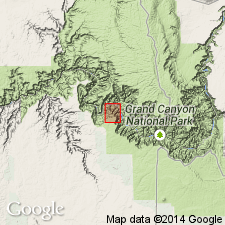
Summary:
Pg. 21, 27. Coconino sandstone of Aubrey group. Coconino sandstone is proposed for the cross-bedded gray to white sandstone of Aubrey group, which is so conspicuous in walls of Grand Canyon. It underlies entire Coconino Plateau, as well as the extensive plateau country north of Grand Canyon. Thickness 50 to 610+/- feet. Underlies Kaibab ("Aubrey") limestone and overlies Supai formation. It is upper part of "Aubrey sandstone series" of early writers. [Subsequently the upper part of Supai formation of Arizona was separated from the Supai and named Hermit shale, so that according to present definition the Coconino sandstone rests on Hermit shale.] [Age is Permian.]
Source: US geologic names lexicon (USGS Bull. 896, p. 480).
- Usage in publication:
-
- Coconino sandstone*
- Modifications:
-
- Age modified
- AAPG geologic province:
-
- Plateau sedimentary province
Summary:
Age of the Coconino sandstone is revised from Pennsylvanian to Permian.
Source: GNU records (USGS DDS-6; Menlo GNULEX).
- Usage in publication:
-
- Coconino sandstone*
- Modifications:
-
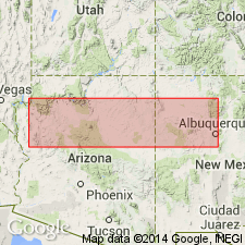
- Areal extent
- Overview
- AAPG geologic province:
-
- Paradox basin
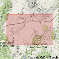
Summary:
Extended to the San Rafael Swell, Emery Co, UT in the Paradox basin. Is a massive, cross-bedded buff to white sandstone 715 ft thick. No determinable fossils have been found. Correlation with type Coconino based on stratigraphic position beneath Kaibab limestone. Coconino of Swell may contain equivalents of Supai formation, Hermit shale, Coconino sandstone, and Kaibab limestone of the Grand Canyon. Assigned to the Permian, and to the Carboniferous [Permian removed from Carboniferous in 194l.]
Source: GNU records (USGS DDS-6; Denver GNULEX).
- Usage in publication:
-
- Coconino sandstone
- Modifications:
-
- Revised
- AAPG geologic province:
-
- Plateau sedimentary province
- Paradox basin
- Great Basin province
Summary:
Revised in that Coconino sandstone underlies the newly named Toroweap formation. Toroweap formerly called subdivisions C, D, and E of Kaibab limestone. Kaibab restricted stratigraphically in this report to the upper Kaibab of earlier reports. No appreciable hiatus is thought to separate the Coconino from the Toroweap. An unconformity where it does exist at the top of the Coconino is with the Kaibab formation of this report. Coconino present in report area in northwest AZ of the Plateau sedimentary province, southwest UT of the Great Basin and Plateau sedimentary provinces, and Paradox basin.
Source: GNU records (USGS DDS-6; Denver GNULEX).
- Usage in publication:
-
- Coconino Sandstone
- Modifications:
-
- Contact revised
- AAPG geologic province:
-
- Black Mesa basin
- Basin-and-Range province
Summary:
Lower contact revised in Fort Apache area, Gila and Navajo Cos, AZ, Basin-and-Range province and Black Mesa basin, where Coconino overlies the newly named Corduroy Member of Supai Formation. Correlation chart. Of Early Permian, Leonardian age.
Source: GNU records (USGS DDS-6; Denver GNULEX).
- Usage in publication:
-
- Coconino Quartzite*
- Modifications:
-
- Redescribed
- Areal extent
- Dominant lithology:
-
- Quartzite
- AAPG geologic province:
-
- Salton basin
Summary:
Names applied in Grand Canyon area extended geographically to sequence in Big Maria Mountains of southeast CA in the Salton basin with change of lithic designation. Permian Coconino Sandstone redescribed as Coconino Quartzite. Coconino is fine-grained vitreous quartzite, white on fresh surfaces, buff where weathered. Cliff-former. Thickness 1-80 meters. Contacts revised; overlies Hermit Schist (redescribed); underlies Kaibab Marble (redescribed). This part of CA was part of stable craton of North America in Paleozoic and early Mesozoic time. Rocks were intruded by Middle Jurassic granodiorite and metamorphosed in Cretaceous time.
Source: GNU records (USGS DDS-6; Denver GNULEX).
- Usage in publication:
-
- Coconino Sandstone
- Modifications:
-
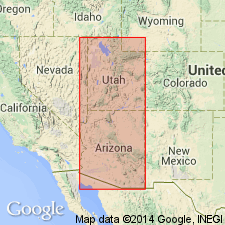
- Revised
- Areal extent
- AAPG geologic province:
-
- Plateau sedimentary province
Summary:
Extends across all of northern and central AZ south of a line from the Defiance Plateau to south of a line from the southern Defiance Plateau to south of the present Monument upwarp. East of a north-south line running through Monument Creek and through Fossil Creek, the formation is undivided. West of this line the upper Coconino and = White Rim Sandstone in UT grade west into Toroweap Formation. Unconformably overlies Hermit Formation. Gradationally overlies Schnebly Hill Formation (new) or De Chelly. Is a cross-stratified, noncalcareous quartzarenite of eolian origin. Divisible in the Sedona and Marble Canyon areas, central AZ, Plateau sedimentary province, into Harding Point Sandstone Member, new at base, and Cave Spring Sandstone Member, new at top. Cross sections. Nomenclature chart.
Source: GNU records (USGS DDS-6; Denver GNULEX).

- Usage in publication:
-
- Coconino Sandstone*
- Modifications:
-
- Reference
- Dominant lithology:
-
- Sandstone
- AAPG geologic province:
-
- Plateau sedimentary province
Summary:
Pg. 22-23 (App. 1). Coconino Sandstone. Chiefly a cliff-forming, white, fine- to medium-grained, cross-bedded sandstone. Thickness 51.6 feet (15.7 m). Unconformably overlies Hermit Shale; unconformably underlies Seligman Member (new) of Toroweap Formation. Age is Permian.
Reference section: beginning on east side of upper Whitmore Canyon, in SW/4 sec. 12, T. 33 N., R. 9 W., [southeast of Woods Ranch, in Mount Logan 7.5-min quadrangle], and ending at top of Hurricane Cliffs [near Mount Trumball], Mohave Co., northern AZ.
Source: Publication.
For more information, please contact Nancy Stamm, Geologic Names Committee Secretary.
Asterisk (*) indicates published by U.S. Geological Survey authors.
"No current usage" (†) implies that a name has been abandoned or has fallen into disuse. Former usage and, if known, replacement name given in parentheses ( ).
Slash (/) indicates name conflicts with nomenclatural guidelines (CSN, 1933; ACSN, 1961, 1970; NACSN, 1983, 2005, 2021). May be explained within brackets ([ ]).