The National Geologic Map Database is migrating to a new infrastructure. We apologize for any service disruptions during this process.
|
|---|


- Usage in publication:
-
- Clear Fork Dacite
- Modifications:
-
- Named
- Dominant lithology:
-
- Dacite
- AAPG geologic province:
-
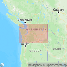
- Cascades province
Summary:
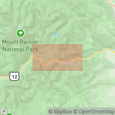
Occurs [Type locality] in glaciated valley of Clear Fork of the Cowlitz River, Lewis Co, WA. Flow forms a broad bench in valley from Coyote Creek to near mouth of Clear Fork, a distance of 8 mi. Composed of very fine textured dacite. Long slender columnar joints, are exposed where flow has been eroded by Clear Fork River. Shown on geologic sketch map of White Pass region. Overlies Ohanapecosh Formation and Russell Ranch Formation. Age is Quaternary.
Source: GNU records (USGS DDS-6; Menlo GNULEX).
- Usage in publication:
-
- Clear Fork dacite
- Modifications:
-
- Geochronologic dating
- AAPG geologic province:
-
- Cascades province
Summary:
Shown on geologic strip sketch map from White Pass to La Grande. Described as light gray dacite, splintery to platy jointed, well developed downward tapering and subdividing columns over 60 m tall. Erupted from vent on east flank of Coal Creek Mountain. Is 75 m thick. Age is <40,000(?) and >20,000(?) yr B.P.
Source: GNU records (USGS DDS-6; Menlo GNULEX).
For more information, please contact Nancy Stamm, Geologic Names Committee Secretary.
Asterisk (*) indicates published by U.S. Geological Survey authors.
"No current usage" (†) implies that a name has been abandoned or has fallen into disuse. Former usage and, if known, replacement name given in parentheses ( ).
Slash (/) indicates name conflicts with nomenclatural guidelines (CSN, 1933; ACSN, 1961, 1970; NACSN, 1983, 2005, 2021). May be explained within brackets ([ ]).