

- Usage in publication:
-
- Cimarron Ridge Formation*
- Modifications:
-
- Named
- Geochronologic dating
- Dominant lithology:
-
- Breccia
- Conglomerate
- Sandstone
- AAPG geologic province:
-
- San Juan Mountains province
Summary:
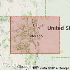
Named for typical exposures along Cimarron Ridge, border of Ouray (San Juan Mountain province) and Gunnison (Paradox basin) Cos, CO. Remains as erosional remnants of a larger volcanic pile that surrounded several volcanoes in the Ouray area south and east of Spruce Ridge. Early Tertiary erosion stripped away most of pile. Appears to extend eastward beneath younger volcanics. Is composed of interbedded green and gray tuff breccia of air-fall and laharic origin and volcanic-derived conglomerate, sandstone, and mudstone ranging in thickness from 0-600 ft. To south consists mostly of green and gray tuff breccia with some flow and flow breccia. The volcanic fragments are mostly finely porphyritic rhyodacite with phenocrysts of zoned plagioclase, brown biotite, pyroxene, quartz, and minor apatite in an aphanitic groundmass. Unconformably overlies Mancos Shale, Fruitland Formation, and Kirtland Shale. Unconformably overlain by Telluride Conglomerate, and San Juan Formation. Maestrichtian, Late Cretaceous age based on pollen and spores and on K-Ar age determination on rhyodacite of 70.1 +/-2.1 m.y. for biotite, 61.5 +/-6.2 m.y. for plagioclase, and 86.9 +/-4.3 m.y. for hornblende.
Source: GNU records (USGS DDS-6; Denver GNULEX).
- Usage in publication:
-
- Cimarron Ridge Formation*
- Modifications:
-
- Areal extent
- AAPG geologic province:
-
- Paradox basin
Summary:
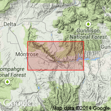
Local remnants mapped in sec 34, T48N, R7W, Montrose Co., CO in the Paradox basin. Is younger than Fruitland Formation and older than West Elk Breccia. Assigned to the Late Cretaceous.
Source: GNU records (USGS DDS-6; Denver GNULEX).
For more information, please contact Nancy Stamm, Geologic Names Committee Secretary.
Asterisk (*) indicates published by U.S. Geological Survey authors.
"No current usage" (†) implies that a name has been abandoned or has fallen into disuse. Former usage and, if known, replacement name given in parentheses ( ).
Slash (/) indicates name conflicts with nomenclatural guidelines (CSN, 1933; ACSN, 1961, 1970; NACSN, 1983, 2005, 2021). May be explained within brackets ([ ]).