

- Usage in publication:
-
- Chupadera formation*
- Modifications:
-
- Overview
- Dominant lithology:
-
- Gypsum
- Shale
- Limestone
- AAPG geologic province:
-
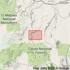
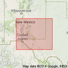
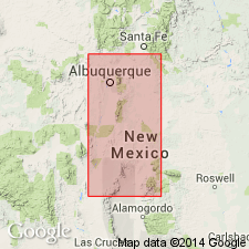
- Orogrande basin
Summary:
Pg. 10-11, 17-18. N.H. Darton's plan of combining San Andreas [San Andres] and Yeso formations under name of Chupadera formation is followed in this report. The plane of separation between Yeso and San Andreas is in many places difficult to locate, and plan of combining them under name of Chupadera formation is especially appropriate in this (Puertecito) district. The massive pink and light-yellow sandstone 150 to 200 feet thick, which is usual top member of old Yeso formation of eastern Socorro County, New Mexico, is absent near Puertecito, where upper part is entirely limestones and gypsum beds, with gypsum predominant; the colors of this part are cream, buff, and light bluish gray. Shaly strata are more abundant in lower part and decrease in amount toward top. Near base the colors are dark gray, yellowish brown, pink, and red. Thickness of formation 1,000 to 1,200 feet. Rests on Abo sandstone, usually conformably. Unconformably underlain by Triassic. Is top formation of Manzano group.
Source: US geologic names lexicon (USGS Bull. 896, p. 441-442).
- Usage in publication:
-
- Chupadera formation*
- Modifications:
-
- Original reference
- Dominant lithology:
-
- Gypsum
- Shale
- Limestone
- AAPG geologic province:
-
- Orogrande basin
- San Juan basin
Summary:
Pg. 176-182. [The name Chupadera formation was adopted by the USGS for this report in July 1919, but report was not published unitl March 31, 1922.] The name Chupadera formation is here introduced for upper part of Manzano group, which Lee divided into Yeso formation and San Andreas [San Andres] limestone. In mapping these deposits it was found that while Lee's subdivisions were discernible in places, it was impracticable to separate them generally. Although limestone is conspicuous feature of San Andres limestone much of that subdivision consists of thick beds of gypsum and sandstone which are not well exposed in the type localities. In future, wherever Lee's subdivisions can be recognized they will be treated as members of Chupadera formation, instead of as distinct formations. Rests on Abo sandstone. Is overlain by Triassic.
Named from Chupadera Mesa [eastern part of Socorro Co., central NM], a prominent topographic feature consisting of a very extensive capping of the formation, 1,500 or more feet thick.
Source: US geologic names lexicon (USGS Bull. 896, p. 441-442).
- Usage in publication:
-
- Chupadera formation*
- Modifications:
-
- Not used
- AAPG geologic province:
-
- Orogrande basin
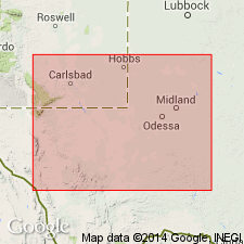
- Permian basin
Summary:
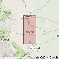
Divided the Permian rocks of Roswell artesian basin, [Chaves, Eddy, and Lincoln Counties], in northeastern New Mexico into (descending): (1) Pecos formation; (2) Picacho limestone (considered to be same as San Andres limestone member of Chupadera formation to west); (3) Nogal formation (considered to be same as Yeso member of Chupadera formation to west).
Source: US geologic names lexicon (USGS Bull. 896, p. 441-442).
- Usage in publication:
-
- Chupadera formation*
- Modifications:
-
- Not used
- AAPG geologic province:
-
- Permian basin
Summary:
Abandoned Pecos formation, dividing it into (descending): Pierce Canyon redbeds, Rustler formation, Salado halite, and Castile anhydrite.
Source: US geologic names lexicon (USGS Bull. 896, p. 441-442).
- Usage in publication:
-
- Chupadera formation*
- Modifications:
-
- Revised
- AAPG geologic province:
-
- Permian basin
Summary:
Chupadera formation. Replaced Picacho limestone with San Andres limestone member of Chupadera formation and replaced Nogal formation, with Hondo sandstone member of Chupadera formation and Yeso member of Chupadera formation (below). The recognition of Hondo sandstone (new) involves a slight redefinition of both San Andres limestone and Yeso.
Source: US geologic names lexicon (USGS Bull. 896, p. 441-442).
- Usage in publication:
-
- Chupadera formation†
- Modifications:
-
- Abandoned
- AAPG geologic province:
-
- Permian basin
Summary:
Pg. 668 (footnote). †Chupadera formation. Term abandoned.
Source: US geologic names lexicon (USGS Bull. 1200, p. 797).
- Usage in publication:
-
- Chupadera formation†
- Modifications:
-
- Abandoned
- AAPG geologic province:
-
- Orogrande basin
Summary:
Pg. 100. Recent mapping has recognized the Yeso, Glorieta, and San Andres formations; term Chupadera has lapsed from usage and should be abandoned.
Source: US geologic names lexicon (USGS Bull. 1200, p. 797).
For more information, please contact Nancy Stamm, Geologic Names Committee Secretary.
Asterisk (*) indicates published by U.S. Geological Survey authors.
"No current usage" (†) implies that a name has been abandoned or has fallen into disuse. Former usage and, if known, replacement name given in parentheses ( ).
Slash (/) indicates name conflicts with nomenclatural guidelines (CSN, 1933; ACSN, 1961, 1970; NACSN, 1983, 2005, 2021). May be explained within brackets ([ ]).