The National Geologic Map Database is migrating to a new infrastructure. We apologize for any service disruptions during this process.
|
|---|


- Usage in publication:
-
- Chopaka basic intrusives
- Modifications:
-
- Named
- Dominant lithology:
-
- Gabbro
- Peridotite
- AAPG geologic province:
-
- Okanogan province
Summary:
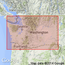
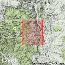
[Probably named from Mt. Chopaka, WA] Shown on sketch map on Mt. Chopaka, north-central WA. Chopaka basic intrusive body cuts Chopaka schist (area of 2 sq mi). Chopaka basic intrusives covers area of 1.25 sq mi. Most of rock consists of normal gabbro transitional to metagabbro and dunite (without chromite). Age is believed to be late Paleozoic (Carboniferous(?)).
Source: GNU records (USGS DDS-6; Menlo GNULEX).
- Usage in publication:
-
- Chopaka Intrusive Complex
- Modifications:
-
- Redescribed
- Geochronologic dating
- AAPG geologic province:
-
- Okanogan province
Summary:
Chopaka Basic Intrusives of Daly (1906, 1912) is referred to as Chopaka Intrusive Complex. Shown on geologic map of Toats Coulee Creek region, Okanogan Range, Washington. Gabbroic gneiss is shown separately from ultramafic rocks. K-Ar analysis on actinolitic hornblende from unit indicates age of 190.5 +/-15.6 Ma. Based on this age, regional metamorphism is Late Triassic. Chopaka Intrusive Complex was emplaced sometime between Permian(?) and Late Triassic, at which time it was involved in regional metamorphism.
Source: GNU records (USGS DDS-6; Menlo GNULEX).
For more information, please contact Nancy Stamm, Geologic Names Committee Secretary.
Asterisk (*) indicates published by U.S. Geological Survey authors.
"No current usage" (†) implies that a name has been abandoned or has fallen into disuse. Former usage and, if known, replacement name given in parentheses ( ).
Slash (/) indicates name conflicts with nomenclatural guidelines (CSN, 1933; ACSN, 1961, 1970; NACSN, 1983, 2005, 2021). May be explained within brackets ([ ]).