

- Usage in publication:
-
- Chocolay group*
- Modifications:
-
- Original reference
- Dominant lithology:
-
- Conglomerate
- Arkose
- Dolomite
- Quartzite
- AAPG geologic province:
-
- Lake Superior region
Summary:
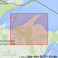
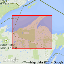
Pg. 30 (table 1), 35. Chocolay group. Oldest of four groups in Animikie series. As defined here, is considered equivalent to Lower Huronian of earlier reports. Comprises (ascending) Fern Creek formation, Sturgeon quartzite, and Randville dolomite and their stratigraphic equivalents. In parts of Iron and Dickinson Counties, only unit of group is Randville dolomite (in southern Iron County, its partial correlative, the Saunders formation); Mesnard quartzite and Kona dolomite, exposed at Mount Chocolay and adjacent area to the west, are accepted as direct correlatives of Sturgeon quartzite and Randville dolomite. Group unconformably overlies post-Dickinson granitic rocks; unconformably underlies Felch formation of Menominee group (reinstated). Age is middle Precambrian (Animikie Series).
Named from Mount Chocolay [not shown on modern topographic map] and Chocolay Junction on the Duluth, South Shore, and Atlantic RR, 3 mi southeast of Marquette, close to southeast corner of Marquette 7.5-min quadrangle, eastern Marquette Co., Northern Peninsula, northwestern MI.
Source: US geologic names lexicon (USGS Bull. 1200, p. 787); supplemental information from GNU records (USGS DDS-6; Denver GNULEX).
- Usage in publication:
-
- Chocolay Group*
- Modifications:
-
- Revised
- AAPG geologic province:
-
- Lake Superior region
- Wisconsin arch
Summary:
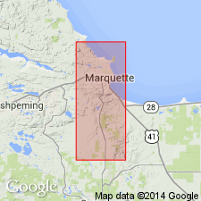
Pg. 27-46. Chocolay Group of Animikie series. Oldest rocks of Animikie series of James (1958) and equivalent to lower Huronian of earlier reports. Chocolay is revised to include newly named Enchantment Lake Formation at its base; rocks were formerly included in Mesnard Quartzite (restricted). In the Marquette and Sands 7.5-min quadrangles, Marquette County, northwestern Michigan (Lake Superior region), the Chocolay is composed of (ascending) Enchantment Lake Formation (new), Mesnard Quartzite (restricted), Kona Dolomite, and Wewe Slate. Unconformably or disconformably underlies Ajibik Quartzite of Menominee Group; unconformably overlies metamorphosed mafic intrusive rocks that may be partly or entirely of Animikie age. Age is middle Precambrian. Report includes geologic maps, correlation chart.
Source: Publication; Changes in stratigraphic nomenclature, 1968 (USGS Bull. 1294-A, p. A5).
- Usage in publication:
-
- Chocolay Group*
- Modifications:
-
- Revised
- AAPG geologic province:
-
- Lake Superior region
Summary:
Pg. 2845 (fig. 2, stratigraphic chart compiled from Leith and others, 1935; James, 1958; Gair and Thaden, 1968). Chocolay Group of James (1958) reassigned to newly named Marquette Range Supergroup (replaces †Animikie series of James, 1958, south of Lake Superior, in Michigan and Wisconsin). In Marquette Range, includes (ascending) Enchantment Lake Formation, Mesnard Quartzite, Kona Dolomite, and Wewe Slate. In Iron River-Crystal Falls district, includes (ascending) Saunders Formation. In Menominee Range, includes (ascending) Fern Creek Formation, Sturgeon Quartzite, and Randville Dolomite. In Gogebic Range, includes (ascending) Sunday Quartzite and Bad River Dolomite. Nonconformable contacts with overlying Menominee Group and underlying lower Precambrian gneisses and greenstones. Age is middle Precambrian.
Source: Publication.
- Usage in publication:
-
- Chocolay Group*
- Modifications:
-
- Revised
- AAPG geologic province:
-
- Lake Superior region
Summary:
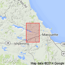
Chocolay Group is revised to include Reany Creek Formation (middle Precambrian) at base as mapped in Negaunee quadrangle, Marquette Co, MI (Lake Superior region). "Metasedimentary rocks of middle Precambrian age form a belt across the southern part of the quadrangle and underlie the Dead River basin in the central and western parts of the quadrangle. The rocks belong to the Chocolay, Menominee, and Baraga Groups of the Marquette Range Supergroup (Cannon and Gair, 1970) and are unconformable on lower Precambrian rocks. The Chocolay Group comprises the Reany Creek Formation, the Enchantment Lake Formation, the Mesnard Quartzite, the Kona Dolomite, and the Wewe Slate." Correlation of map units (pl. 1) shows Reany Creek correlative with Enchantment Lake Formation at base of Chocolay. Text (p. 23) notes Reany Creek is similar to Enchantment Lake Formation in Marquette syncline, hence might be correlative with lower part of Marquette Range Supergroup; but no meaningful age data on which to base a correlation.
Source: GNU records (USGS DDS-6; Denver GNULEX).
For more information, please contact Nancy Stamm, Geologic Names Committee Secretary.
Asterisk (*) indicates published by U.S. Geological Survey authors.
"No current usage" (†) implies that a name has been abandoned or has fallen into disuse. Former usage and, if known, replacement name given in parentheses ( ).
Slash (/) indicates name conflicts with nomenclatural guidelines (CSN, 1933; ACSN, 1961, 1970; NACSN, 1983, 2005, 2021). May be explained within brackets ([ ]).