The National Geologic Map Database is migrating to a new infrastructure. We apologize for any service disruptions during this process.
|
|---|


- Usage in publication:
-
- Chinquapin Metabasalt Member*
- Modifications:
-
- Named
- Dominant lithology:
-
- Metavolcanics
- AAPG geologic province:
-
- California Coast Ranges province
Summary:
Pg. C5. Chinquapin Metabasalt Member of South Fork Mountain Schist (new). Consists of metabasaltic rocks. Occurs as mappable, discontinuous lenses throughout South Fork Mountain Schist. Metamorphic age of South Fork Mountain Schist is believed to be Late(?) Cretaceous.
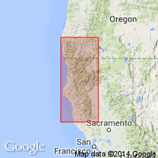
Type locality: Chinquapin Butte, in sec. 21, T. 28 N., R. 8 E., and sec. 18 T. 28 N., R. 12 W., in southeast corner of Pickett Peak 15-min quadrangle, Trinity Co., northern CA. Origin of name not stated by authors, but probably named from Chinquapin Butte.
Source: US geologic names lexicon (USGS Bull. 1350, p. 150); supplemental information from GNU records (USGS DDS-6; Menlo GNULEX).
- Usage in publication:
-
- Chinquapin Metabasalt Member*
- Modifications:
-
- Revised
- AAPG geologic province:
-
- California Coast Ranges province
Summary:
Chinquapin Metabasalt Member of South Fork Mountain Schist mapped as part of Franciscan assemblage west of Coast Range thrust, in Colyear Springs 15-min quadrangle, Tehama County California. Described as metavolcanic rock, blueschist including metatuff and massive metabasalt.
Source: Modified from GNU records (USGS DDS-6; Menlo GNULEX).
- Usage in publication:
-
- Chinquapin Metabasalt Member*
- Modifications:
-
- Age modified Geochronologic dating
- AAPG geologic province:
-
- California Coast Ranges province
Summary:
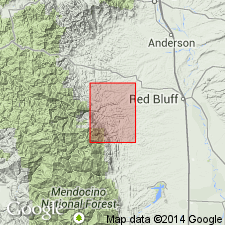
Chinquapin Metabasalt Member of South Fork Mountain Schist. Samples collected from Yolla Bolly area and Pickett Peak 15-min quadrangle, Trinity Co., CA. Radiometric age dates suggest South Fork Mountain Schist and its Chinquapin Metabasalt Member formed during Early Cretaceous metamorphic event. Whole-rock K-Ar ages range from 130 to 112 m.y.; best estimate 120 to 115 m.y.
Source: Modified from GNU records (USGS DDS-6; Menlo GNULEX).

- Usage in publication:
-
- Chinquapin Metabasalt Member*
- Modifications:
-
- Geochronologic dating
- AAPG geologic province:
-
- California Coast Ranges province
Summary:
Pg. 7, geologic time scale (inside front cover). Chinquapin Metabasalt Member of South Fork Mountain Schist. Samples from Pickett Peak and Yolla Bolly quadrangles, Trinity County, California, yielded K-Ar ages (crossite) of 134 +/-20 Ma (apparently too young) and 89 +/-13 Ma (anomalously young), respectively. Ages calculated using decay constants of Steiger and Jager, 1977 (Earth Planet. Sci. Letters, v. 36, p. 359-362). Probable age of metamorphism is 150 Ma (citing Coleman and Lanphere, 1971, GSA Bull., v. 82, p. 2397-2412). [Lanphere and others, 1978 (Amer. Jour. Sci., v. 278, no. 6, p. 798-815) believe South Fork Mountain Schist and its Chinquapin Metabasalt Member formed during an Early Cretaceous metamorphic event. Whole-rock K-Ar ages range from 130 to 112 Ma; best estimate 120 to 115 Ma.]
Source: Publication; supplemental information from GNU records (USGS DDS-6; Menlo GNULEX).
For more information, please contact Nancy Stamm, Geologic Names Committee Secretary.
Asterisk (*) indicates published by U.S. Geological Survey authors.
"No current usage" (†) implies that a name has been abandoned or has fallen into disuse. Former usage and, if known, replacement name given in parentheses ( ).
Slash (/) indicates name conflicts with nomenclatural guidelines (CSN, 1933; ACSN, 1961, 1970; NACSN, 1983, 2005, 2021). May be explained within brackets ([ ]).