The National Geologic Map Database is migrating to a new infrastructure. We apologize for any service disruptions during this process.
|
|---|


- Usage in publication:
-
- Chicken Ridge Sandstone Member*
- Modifications:
-
- Original reference
- Dominant lithology:
-
- Sandstone
- AAPG geologic province:
-
- Piedmont-Blue Ridge province
Summary:
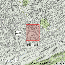
The Chicken Ridge Sandstone Member of the Kanawha Formation, here named, is in the Jewell Ridge quadrangle in Buchanan and Tazewell Counties, southwestern Virginia. Occurs near the base of the Kanawha and underlies 4 feet of shale and underclay beneath the Bearwallow coal bed. Thickness is 20 feet. Age is Middle Pennsylvanian.
Source: US geologic names lexicon (USGS 1565, p. 61).
For more information, please contact Nancy Stamm, Geologic Names Committee Secretary.
Asterisk (*) indicates published by U.S. Geological Survey authors.
"No current usage" (†) implies that a name has been abandoned or has fallen into disuse. Former usage and, if known, replacement name given in parentheses ( ).
Slash (/) indicates name conflicts with nomenclatural guidelines (CSN, 1933; ACSN, 1961, 1970; NACSN, 1983, 2005, 2021). May be explained within brackets ([ ]).