The National Geologic Map Database is migrating to a new infrastructure. We apologize for any service disruptions during this process.
|
|---|


- Usage in publication:
-
- Chickachoc chert lentil*
- Modifications:
-
- Original reference
- Dominant lithology:
-
- Sandstone
- Chert
- Limestone
- AAPG geologic province:
-
- Arkoma basin
Summary:
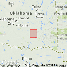
Chickachoc chert lentil, near base of Atoka formation. White, calcareous, stratified but massive, cherty sandstone, 0 to 80 feet thick. Separately mapped in southeastern corner of Coalgate quadrangle, Coal County, south-central Oklahoma. Age is Carboniferous.
Source: US geologic names lexicon (USGS Bull. 896, p. 425); supplemental information from GNU records (USGS DDS-6; Denver GNULEX).

- Usage in publication:
-
- Chickachoc chert lentil*
- Modifications:
-
- [Principal reference]
Summary:
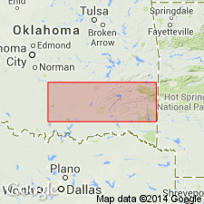
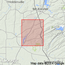
Chickachoc chert lentil of Atoka formation. Occurs in southeastern part of Coalgate quadrangle, extreme northeast corner of Atoka quadrangle, and in southeastern part of McAlester quadrangle, Oklahoma.
Named from post office called Chickachoc in 1901 and located at or near present station of Chockie, on Missouri, Kansas, and Texas RR, just east of border of Coalgate quadrangle and near type exposures of the chert lentil. (Letter from J.A. Taff dated Jan. 26, 1931.)
Source: US geologic names lexicon (USGS Bull. 896, p. 425).
- Usage in publication:
-
- Chickachoc chert lentil
- Modifications:
-
- Not used
- AAPG geologic province:
-
- Arkoma basin
Summary:
Pg. 903. [Chickachoc chert lentil of Atoka formation.] In extreme northwestern Ouachitas of Oklahoma, this formation [Wapanucka], together with the Barnett Hill formation (new), as well as the Primrose formation, was erroneously designated by Taff, 1902 (USGS Geol. Atlas, Folio no. 79, Atoka quadrangle) [1901, USGS Geol. Atlas, Folio no. 74, Coalgate quadrangle] as Chickachoc chert lentil. Since proper position of beds, now designated as Primrose, Wapanucka, and Barnett Hill, has been established, it seems advisable to discard Chickachoc as a formational name.
Source: US geologic names lexicon (USGS Bull. 1200, p. 758); supplemental information from GNU records (USGS DDS-6; Denver GNULEX).
- Usage in publication:
-
- Chickachoc chert*
- Modifications:
-
- Revised
- Adopted
Summary:
Sheet 3. Chickachoc Chert. Rank raised to formation. Described in block southeast of Katy Club fault in western part of Ouachita Mountains where it overlies Springer formation and underlies Atoka formation. Consists of greenish gray to tan clay shale that weathers to a tan clay and contains beds and lenses of spiculite; where fresh, spiculite is dark bluish gray and very hard; where weathered, resembles a coarse-grained sandstone or porous chert. As many as 10 beds of spiculite, each more than 5 feet thick, are present locally. In general, base of a bed of spiculite, about 10 feet thick, is assumed to be base of formation; a bed of spiculite 20 to 50 feet thick is present in middle part; a massive spiculite bed 30 to 120 feet thick constitutes top member. Estimated thickness 600 feet. Age is Pennsylvanian.
Source: US geologic names lexicon (USGS Bull. 1200, p. 758).
For more information, please contact Nancy Stamm, Geologic Names Committee Secretary.
Asterisk (*) indicates published by U.S. Geological Survey authors.
"No current usage" (†) implies that a name has been abandoned or has fallen into disuse. Former usage and, if known, replacement name given in parentheses ( ).
Slash (/) indicates name conflicts with nomenclatural guidelines (CSN, 1933; ACSN, 1961, 1970; NACSN, 1983, 2005, 2021). May be explained within brackets ([ ]).