The National Geologic Map Database is migrating to a new infrastructure. We apologize for any service disruptions during this process.
|
|---|


- Usage in publication:
-
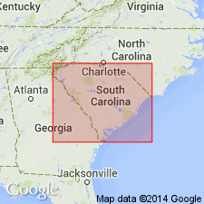
- Cherokee zone
- Modifications:
-
- Original reference
- AAPG geologic province:
-
- Piedmont-Blue Ridge province
Summary:
[Synopsis from advance copy of South Carolina Geol. Survey geognostic map of South Carolina published 1908, in South Carolina Geol. Survey Bull., 4th ser., no. 2, and 1907, Summary of mineral resources of South Carolina, p. 6, 11, 12.]
Cherokee zone (Cambrian?). This zone comprises a small area bounded on southeast by a line which extends southwest from point where King's Creek crosses the North Carolina line, by Silver Mountain across Broad Blver, and thence across Thicketty Creek below mouth of Limestone Creek to a point west of their conflnence, where it encounters Anderson-Spartanburg zone; which zone thence bounds it on west and northwest to North Carolina line; the State line constitutes the bdy on north. Some corresponding formations of probable equivalence are interruptedly exposed in a narrow, much obscured band, which extends towards Saluda River, along the line which separates Anderson-Spartanburg zone from Abbeville-York zone, across Laurens County; exhibited at Frenchman's Creek, at Mahaffey Kiln, at Masters Kiln and at Raysors Kiln. Siliceous slates (slightly carbonic), quartzite, hornblende slates variously merging to limestone, and marble; ottrelite schists; itacolumite; slates interbedded with hematite; lithia granite; gneiss; black slates; mica slates; metamorphosed igneous magnesium rocks with lenticles of magnetite and bodies of asbestos; siliceous and magnesium hematite, and specular iron ores intercalated with slates; massive fine grained gray mica slates; intrusive diabase (distinctly foliated).
Probably named for exposures in Cherokee Co., northwestern SC.
Source: US geologic names lexicon (USGS Bull. 896, p. 415-416).
For more information, please contact Nancy Stamm, Geologic Names Committee Secretary.
Asterisk (*) indicates published by U.S. Geological Survey authors.
"No current usage" (†) implies that a name has been abandoned or has fallen into disuse. Former usage and, if known, replacement name given in parentheses ( ).
Slash (/) indicates name conflicts with nomenclatural guidelines (CSN, 1933; ACSN, 1961, 1970; NACSN, 1983, 2005, 2021). May be explained within brackets ([ ]).