The National Geologic Map Database is migrating to a new infrastructure. We apologize for any service disruptions during this process.
|
|---|


- Usage in publication:
-
- Chelmsford Granite*
- Modifications:
-
- Age modified
- Areal extent
- Overview
- AAPG geologic province:
-
- New England province
Summary:
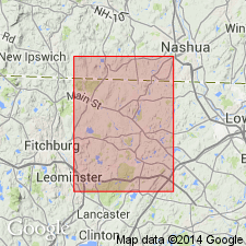
Chelmsford Granite extended from northern MA to southern NH. Follows usage of Lyons and Faul (1977). Age is refined to Early Devonian. Consists of white to light-gray, mildly to well-foliated, fine- to coarse-grained, locally pegmatitic or micropegmatitic oligoclase-quartz-microcline-(biotite)-(muscovite) granite.
Source: GNU records (USGS DDS-6; Reston GNULEX).
- Usage in publication:
-
- Chelmsford Granite*
- Modifications:
-
- Overview
- Geochronologic dating
- AAPG geologic province:
-
- New England province
Summary:
Gore (1976) included the Chelmsford Granite in his "Ayer crystalline complex", suggesting that the Chelmsford and Ayer are related. Age is Early Devonian, based on radiometric dating of about 383 m.y. (R.E. Zartman, and R.S. Naylor, written commun., 1978). It cuts the Devens-Long Pond facies of Ayer Granite and may be genetically related to Clinton facies of the Ayer; however, Chelmsford should be a separate unit because of its age designation and composition. Usage should follow that of Robinson (1978).
Source: GNU records (USGS DDS-6; Reston GNULEX).

- Usage in publication:
-
- Chelmsford Granite*
- Modifications:
-
- Overview
- AAPG geologic province:
-
- New England province
Summary:
Used as Chelmsford Granite of Early Devonian age. Intrudes Berwick Formation.
Source: GNU records (USGS DDS-6; Reston GNULEX).
- Usage in publication:
-
- Chelmsford Granite*
- Modifications:
-
- Overview
- Geochronologic dating
- AAPG geologic province:
-
- New England province
Summary:
Chelmsford Granite intrudes Berwick Formation, Ayer Granite, and Dracut Diorite northwest of Clinton-Newbury fault. Occurs as two elongate, northeast-striking bodies occupying an area of 60 sq km. Described as light colored and gneissic. Zartman and Naylor (1984) could not obtain a definitive age but believed Chelmsford was in same age range as Ayer because the age of the Chelmsford lay within margin of error for their age determinations. Devonian age shown on MA State geologic map is based on their Pb-Pb age of 389 +/-5 Ma. [Papers presented as chapters in U.S. Geological Survey Professional Paper 1366 are intended as explanations and (or) revisions to MA State bedrock geologic map of Zen and others (1983) at scale of 1:250,000.]
Source: GNU records (USGS DDS-6; Reston GNULEX).

- Usage in publication:
-
- Chelmsford Granite*
- Modifications:
-
- Overview
- Revised
- AAPG geologic province:
-
- New England province
Summary:
Used as Chelmsford Granite and included within New Hampshire Plutonic Suite on 1:500,000-scale derivative map showing plutons. Not separately mapped on 1:250,000-scale geologic map. [No age given.]
Source: GNU records (USGS DDS-6; Reston GNULEX).
For more information, please contact Nancy Stamm, Geologic Names Committee Secretary.
Asterisk (*) indicates published by U.S. Geological Survey authors.
"No current usage" (†) implies that a name has been abandoned or has fallen into disuse. Former usage and, if known, replacement name given in parentheses ( ).
Slash (/) indicates name conflicts with nomenclatural guidelines (CSN, 1933; ACSN, 1961, 1970; NACSN, 1983, 2005, 2021). May be explained within brackets ([ ]).