

- Usage in publication:
-
- Charlton formation
- Modifications:
-
- Named
- Dominant lithology:
-
- Limestone
- Clay
- AAPG geologic province:
-
- South Georgia sedimentary province
- Florida platform
Summary:
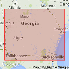
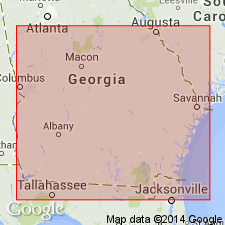
Charlton formation named in Charlton Co., southeastern GA. Extends along St. Marys River to extreme northeastern FL. Unit is soft, white, argillaceous limestone and laminated fossiliferous, greenish clay, exposed in banks and bluffs of St. Marys River, from Stokes Ferry, 11 mi south of St. George, Charlton Co., GA to Orange Bluff, near Kings Ferry, FL. From studies of fossils, Dr. Vaughan has classified the formation as probably Pliocene. Older than Okefenokee and Satilla formations (Pleistocene). Thickness undetermined as only 12 or 15 ft seen in natural exposures.
Source: GNU records (USGS DDS-6; Reston GNULEX).
- Usage in publication:
-
- Charlton formation*
- Modifications:
-
- Age modified
- AAPG geologic province:
-
- South Georgia sedimentary province
Summary:
Charlton formation mapped in GA as Pliocene (no query).
Source: GNU records (USGS DDS-6; Reston GNULEX).
- Usage in publication:
-
- Charlton formation
- Modifications:
-
- Age modified
- AAPG geologic province:
-
- Florida platform
Summary:
Pg. 58, 59. Charlton formation. Prior to 1942, Pliocene series in Florida was considered composed of Citronelle formation, Tamiami limestone, Buckingham marl, Bone Valley gravel, Alachua formation, Charlton formation, and Caloosahtchee marl. Additional well data and fieldwork has presented evidence that places beds formerly called Tamiami limestone, Buckingham marl, and upper beds of Hawthorn into Tamiami formation. The Charlton is similar in fauna and lithology to the Buckingham and is also placed in the upper Miocene.
Source: US geologic names lexicon (USGS Bull. 1200, p. 726).
- Usage in publication:
-
- Charlton Formation
- Modifications:
-
- Age modified
- AAPG geologic province:
-
- South Georgia sedimentary province
Summary:
Age of Charlton Formation is Pliocene. [Several other references during the 1960's and 1970's give the age of the Charlton as Pliocene including the 1976 State map of GA.]
Source: GNU records (USGS DDS-6; Reston GNULEX).
- Usage in publication:
-
- Charlton Member
- Modifications:
-
- Revised
- AAPG geologic province:
-
- Florida platform
- South Georgia sedimentary province
Summary:
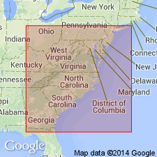
Charlton Formation of Veatch and Stephenson (1911) is here revised, redefined, and reduced in rank to member. It is assigned to the Coosawhatchie is this report because it grades both laterally and downsection into the typical Coosawhatchie sediments of the Ebenezer Member (new name). As a continuous mappable unit, the Charlton is restricted to parts of Camden, Charlton, and Brantley Cos., GA, and to parts of Nassau, Duval, Baker, Bradford, and Clay Cos., FL. Typical Charlton consists of clay, dolostone, and limestone; almost absent are sand and phosphate. Disconformably underlies the Cypresshead Formation (new name) in most areas. Conformably and gradationally overlies the Ebenezer Member. Thickness at the reference core Charlton 2 (GGS-3185) at Folkston is 79 ft (24 m). Thickness of 6 ft (2 m) reported by Veatch and Stephenson at Stokes Bridge. Though unit is exceptionally fossiliferous for a unit of the Hawthorne, species are of little value for biostratigraphic correlation. Charlton is provisionally assigned the same age as the rest of the Coosawhatchie, middle Miocene, based on stratigraphic relationships. There is no paleontological evidence for a post-Miocene age. Late Miocene age suggested by Waller (1969) is not excluded.
Source: GNU records (USGS DDS-6; Reston GNULEX).
- Usage in publication:
-
- Charlton Member
- Modifications:
-
- Reference
- AAPG geologic province:
-
- Florida platform
Summary:
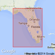
A FL reference section for the Charlton Member of the Coosawhatchie Formation is designated in the Cassidy #1 core, W-13815, Nassau Co (NW1/4NW1/4 sec. 32, T3N, R24E. Interval is between -13 m and +1 m. This is the maximum thickness recorded in FL. Unit both overlies and interfingers laterally with the upper informal member of the Coosawhatchie, of which it is simply a distinctive facies. Sediments assigned to the Charlton Member were referred to as the "Jacksonville limestone" by Dall and Harris (1892) and the "Jacksonville formation" by Matson (1915). Cooke (1945) suggested the "Jacksonville formation" be placed in the Duplin Marl. Use of Charlton Member rather than reintroducing the "Jacksonville" is suggested here to be consistent with the nomenclature of the Georgia coastal plain. Reduction in rank is necessary because of its limited extent.
Source: GNU records (USGS DDS-6; Reston GNULEX).
For more information, please contact Nancy Stamm, Geologic Names Committee Secretary.
Asterisk (*) indicates published by U.S. Geological Survey authors.
"No current usage" (†) implies that a name has been abandoned or has fallen into disuse. Former usage and, if known, replacement name given in parentheses ( ).
Slash (/) indicates name conflicts with nomenclatural guidelines (CSN, 1933; ACSN, 1961, 1970; NACSN, 1983, 2005, 2021). May be explained within brackets ([ ]).