The National Geologic Map Database is migrating to a new infrastructure. We apologize for any service disruptions during this process.
|
|---|


- Usage in publication:
-
- Chamiso formation*
- Modifications:
-
- Original reference
- Dominant lithology:
-
- Sandstone
- Shale
- Coal
- AAPG geologic province:
-
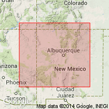
- Basin-and-Range province
- Orogrande basin
Summary:
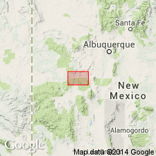
Chamiso formation. Soft yellow sandstones and sandy shales with intercalated carbonaceous beds and coal beds at 3 general horizons, the on 75 feet above base being important. Wholly nonmarine. Abundant Mesaverde flora but no invertebrates. Probably includes rocks older than Mesaverde, hence local name. Thickness 1,850 feet. Rests on Bell Mountain sandstone member of Miguel formation and unconformably underlies Datil formation (late Tertiary). Age is Late Cretaceous. Recognized in Alamaso Creek Valley [now Alamocita Creek] area, Socorro [and Catron] Cos., southwestern NM.
Named from Chamiso Creek [now Chamisa Canyon], in T. 2 N., R. 9 W., Socorro Co. [Catron Co.], southwestern NM. [Chamisa Canyon is in Catron County (est. Feb. 1921), Magdalena quadrangle, scale 1:100,000.]
Source: US geologic names lexicon (USGS Bull. 896, p. 396).
- Usage in publication:
-
- Chamiso member
- Modifications:
-
- Revised
- AAPG geologic province:
-
- Basin-and-Range province
- Orogrande basin
Summary:
Pg. 71, 74 (sections 60 and 61, D-Cross Mountain). Chamiso member of Mesaverde formation. Winchester's Chamiso formation, comprising 1,850 feet of continental rocks of Montana age overlying Bell Mountain sandstone, is here reduced to rank of member in Mesaverde formation. [Age is Late Cretaceous.]
Section measured on north bank of Alamosa Creek [now Alamocita Creek], in sec. 36, T. 3 N., R. 9 W., [D Cross Mountain 7.5-min quadrangle], Catron Co., southwestern NM.
Source: Publication; US geologic names lexicon (USGS Bull. 1200, p. 713-714).
- Usage in publication:
-
- Chamiso formation†
- Modifications:
-
- Abandoned
- AAPG geologic province:
-
- Basin-and-Range province
- Orogrande basin
Summary:
Pg. 191. †Chamiso formation abandoned in favor of Crevasse Canyon formation for Alamosa Creek [now Alamocita Creek] area, southwestern New Mexico.
Source: US geologic names lexicon (USGS Bull. 1200, p. 713-714).
For more information, please contact Nancy Stamm, Geologic Names Committee Secretary.
Asterisk (*) indicates published by U.S. Geological Survey authors.
"No current usage" (†) implies that a name has been abandoned or has fallen into disuse. Former usage and, if known, replacement name given in parentheses ( ).
Slash (/) indicates name conflicts with nomenclatural guidelines (CSN, 1933; ACSN, 1961, 1970; NACSN, 1983, 2005, 2021). May be explained within brackets ([ ]).