The National Geologic Map Database is migrating to a new infrastructure. We apologize for any service disruptions during this process.
|
|---|


- Usage in publication:
-
- Chamberlain Pass Formation
- Modifications:
-
- Named
- Dominant lithology:
-
- Sandstone
- Mudstone
- AAPG geologic province:
-
- Sioux uplift
- Williston basin
Summary:
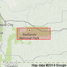
The fluvial middle(?) and late Eocene Chamberlain Pass Formation is here named and assigned to the basal part of Eocene and Oligocene White River Group (revised). Type section is designated among excellent exposures just east of Badlands National Park, at Chamberlain Pass NW1/4 sec 35, T2S, R20E, Jackson Co, west-central SD. Named for local landmark. Ranges west to Pennington Co, SD, as shown in Scenic and Wall measured sections. Has wedge-like geometry, thickening eastward, while its mudstones present a sheet-like appearance that persists throughout the region. Sandstone outcrops are isolated buttes, locally common and well-displayed. Consists of white, cross-bedded channel sandstones and pale-olive to pale-red overbank mudstones. Sandstones typically have a basal conglomerate consisting of quartz, quartzite, and chert clasts. Mudstones contain red sesquioxide nodules, contrasting strongly with brownish-yellow color of the underlying (but sometimes incorporated) [informal] Late Cretaceous Yellow Mounds Paleosol, which is altered Pierre Shale (Retallack, 1983; Terry, 1991). Brecciation decreases downward into the Chamberlain Pass, which transforms unit into large, clay-filled fractures giving mosaic appearance to an outcrop. Thickness at type is 11.5 m. Unconformably underlain by Late Cretaceous Pierre Shale (revised) and/or the Yellow Mounds. Sharply unconformable with the overlying late Eocene and early Oligocene Chadron Formation (revised) of the White River Group. Best available data constrain age as middle(?) and late Eocene. Although the Chamberlain Pass has not been directly dated by radiometric methods, the Late Cretaceous age of underlying Pierre is based on biostratigraphy. The overlying Chadron is late Eocene and early Oligocene in age (+/-36.5 Ma to 34 Ma), based upon 40Ar/39Ar dating of tephras (Swisher and Prothero, 1990), magnetostratigraphy (Prothero, 1985, 1989), and land mammal faunal ages (Emry and others, 1987). [This study quotes the North American Stratigraphic Code (1983) when it calls the unconformity-bound Chamberlain Pass Formation an "alloformation" and "allostratigraphic unit"; however, such terms seem to be descriptive only and are not appended to the formal name. In addition, Figure 2 implies that the Chamberlain Pass includes the Interior Paleosol as used by Retallack (1983).] Report includes geologic sketch map, columnar section, and measured sections.
Source: GNU records (USGS DDS-6; Denver GNULEX).
- Usage in publication:
-
- Chamberlain Pass Formation
- Modifications:
-
- Age modified
- Biostratigraphic dating
- Revised
- AAPG geologic province:
-
- Sioux uplift
- Williston basin
Summary:
Age of Chamberlain Pass Formation of the Eocene and Oligocene White River Group is most likely middle to late Eocene (instead of middle(?) and late Eocene of Evans and Terry, 1994). Here, age determination is based on scraps of bone recovered by Clark and others (1967) from the Chamberlain Pass near Weta, SD, and tentatively identified as TRIGONIAS or a small titanothere, and a collection of Chadronian-age fossils from similar sediments north of East Short Pine Hills, southwestern Harding Co, SD, (Lillegraven, 1970). Color, mineralogy, and horizons suggest that soils developed within the channel and proximal overbank deposits of the Chamberlain Pass merit classification as a new soil series. Herein, they are designated [informal] Weta Paleosol Series, named for the town, now deserted, but located directly west of type section of the Chamberlain Pass (revised). Research has demonstrated that the Weta, together with [informal] Interior Paleosol Series of Retallack (1983), developed within the same parent material and represent a soil catena. Base of the Weta soil profile starts approximately 8.5 m above [informal] Yellow Mounds Paleosol Series [of underlying Late Cretaceous Pierre Shale]. Report includes measured section.
Source: GNU records (USGS DDS-6; Denver GNULEX).
For more information, please contact Nancy Stamm, Geologic Names Committee Secretary.
Asterisk (*) indicates published by U.S. Geological Survey authors.
"No current usage" (†) implies that a name has been abandoned or has fallen into disuse. Former usage and, if known, replacement name given in parentheses ( ).
Slash (/) indicates name conflicts with nomenclatural guidelines (CSN, 1933; ACSN, 1961, 1970; NACSN, 1983, 2005, 2021). May be explained within brackets ([ ]).