The National Geologic Map Database is migrating to a new infrastructure. We apologize for any service disruptions during this process.
|
|---|


- Usage in publication:
-
- Chalk Hills member
- Modifications:
-
- Original reference
- AAPG geologic province:
-
- Arkla basin
Summary:
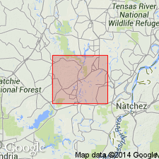
Pg. 122-124. Chalk Hills member of Catahoula formation. Name given to bed of white or cream-colored volcanic ash or tuff about 8 feet thick that occurs near the top of formation. Separated from underlying Cassel Hill member (new) by an interval of gray tuff or tuffaceous siltstone, and massive medium- to coarse-grained sandstone. Age is Miocene.
Prominently exposed in the Chalk Hills through secs. 7, 16, 17, 18 and 21, T. 10 N., R. 5 E., Catahoula Parish, east-central LA. Extends westward into La Salle Parish and then thins out.
Source: US geologic names lexicon (USGS Bull. 896, p. 709).
For more information, please contact Nancy Stamm, Geologic Names Committee Secretary.
Asterisk (*) indicates published by U.S. Geological Survey authors.
"No current usage" (†) implies that a name has been abandoned or has fallen into disuse. Former usage and, if known, replacement name given in parentheses ( ).
Slash (/) indicates name conflicts with nomenclatural guidelines (CSN, 1933; ACSN, 1961, 1970; NACSN, 1983, 2005, 2021). May be explained within brackets ([ ]).