The National Geologic Map Database is migrating to a new infrastructure. We apologize for any service disruptions during this process.
|
|---|


- Usage in publication:
-
- Central Plateau Member*
- Modifications:
-
- Named
- Geochronologic dating
- Dominant lithology:
-
- Lava
- AAPG geologic province:
-
- Yellowstone province
Summary:
Pg. B4 (fig. 2), B6 (table 1), B13-B14. Central Plateau Member of Plateau Rhyolite (new). Includes late postcaldera rhyolitic lava flows erupted from vents within the Yellowstone caldera. Constitutes greatest part of total volume of Plateau Rhyolite. Forms the Madison, Pitchstone, Central, and Solfatara Plateaus. Eighteen flows and domes identified. Some of the flows are 300+ m thick and few extend more than 20 km from their source vents. Flows have 30 to 50 percent phenocrysts, most of which are quartz and sanidine with no plagioclase. All contain in their glassy portions minor clinopyroxene, opaque oxides, and fayalitic olivine. Overlies Obsidian Creek, Upper Basin, and Mallard Lake Members (all new) of Plateau Rhyolite, or Lava Creek Tuff (new) of Yellowstone Group (rank raised). Age is late Quaternary (Pleistocene). K-Ar age determinations on sanidine range from about 200,000 to 70,000 years (citing J.D. Obradovich, written commun., 1970). Report includes stratigraphic table, cross section.
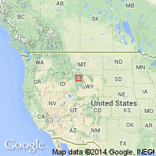
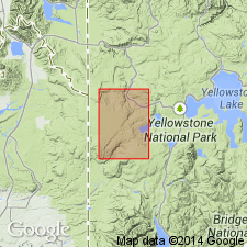
Type area: Central Plateau located in the middle of the Yellowstone caldera, west-central Yellowstone National Park, Park Co., northwestern WY (Yellowstone province). Named from Central Plateau.
Source: Publication; US geologic names lexicon (USGS Bull. 1520, p. 15); GNU records (USGS DDS-6; Denver GNULEX).
- Usage in publication:
-
- Central Plateau Member*
- Modifications:
-
- Revised
- AAPG geologic province:
-
- Yellowstone province
Summary:
Central Plateau Member of Plateau Rhyolite. Stratigraphically extended to include unnamed tuffs of Cold Mountain Creek (Old Faithful quadrangle) and Bluff Point (Norris Junction quadrangle), both formerly included in †Shoshone Lake Tuff Member of Plateau (now abandoned). Age is Pleistocene. Study area in Yellowstone National Park, Wyoming.
See also R.L. Christiansen, 1974, Geol. map West Thumb quad., Yellowstone Natl. Park, WY, USGS Geol. Quad. Map GQ-1191; R.L. Christiansen, 1975, Geol. map Norris Junction quad., Yellowstone Natl. Park, WY, USGS Geol. Quad. Map GQ-1193.
Source: Changes in stratigraphic nomenclature, 1975 (USGS Bull. 1422-A, p. A6-A7, A36-A37).
For more information, please contact Nancy Stamm, Geologic Names Committee Secretary.
Asterisk (*) indicates published by U.S. Geological Survey authors.
"No current usage" (†) implies that a name has been abandoned or has fallen into disuse. Former usage and, if known, replacement name given in parentheses ( ).
Slash (/) indicates name conflicts with nomenclatural guidelines (CSN, 1933; ACSN, 1961, 1970; NACSN, 1983, 2005, 2021). May be explained within brackets ([ ]).