

- Usage in publication:
-
- Central Plains orogen
- Modifications:
-
- Overview
- AAPG geologic province:
-
- Midcontinent region
- Southwestern Basin-and-Range region
- Southern Rocky Mountain region
Summary:
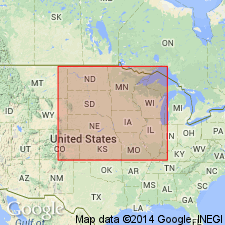
In the northern Midcontinent [Midcontinent region], is an arcuate belt of metamorphic and granitoid rocks at least 400 km wide that is reflected by conspicuous linear magnetic and gravity anomalies. Sims and Peterman (1986) suggested that the orogen correlates with the Early Proterozoic foldbelt exposed in basement uplifts of CO and southern WY, and accordingly it is part of a wide, continuous foldbelt extending through northern AZ and NM into CA (Silver and others, 1977) [Southern Rocky Mountain region and Southwestern Basin-and-Range region]. Areal limits in the northern Midcontinent shown on tectonic map of Precambrian basement (fig. 3). Age shown to be about 1.65 Ga (Early Proterozoic).
Source: GNU records (USGS DDS-6; Denver GNULEX).
For more information, please contact Nancy Stamm, Geologic Names Committee Secretary.
Asterisk (*) indicates published by U.S. Geological Survey authors.
"No current usage" (†) implies that a name has been abandoned or has fallen into disuse. Former usage and, if known, replacement name given in parentheses ( ).
Slash (/) indicates name conflicts with nomenclatural guidelines (CSN, 1933; ACSN, 1961, 1970; NACSN, 1983, 2005, 2021). May be explained within brackets ([ ]).