

- Usage in publication:
-
- Cejita Member*
- Modifications:
-
- Named
- Dominant lithology:
-
- Conglomerate
- Sand
- AAPG geologic province:
-
- San Juan basin
Summary:
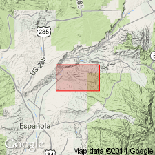
Named as a member of Tesuque Formation of Santa Fe Group for exposures in T22N, R10E, on south side of Mesa de la Cejita, Tampas quad, Rio Arriba Co, NM in the San Juan basin. These exposures are designated the type section. Consists of grayish-brown, well-sorted and rounded coarse conglomerate and interbedded coarse- and fine-grained sands. Clasts are Precambrian quartzite (5-65 percent) and granite (+/-5 percent), Paleozoic sedimentary rocks (30-95 percent) and trace amounts of quartz and of Tertiary intermediate to silicic volcanic rocks. Maximum clast size 1.2 m. Weakly cemented by calcium carbonate. Large-scale cross-bedding locally. Individual beds are as much as 37 m thick. Ranges from 1.5 to 140 m thick. Thickens northward. Overlies eolian sand of Tesuque; underlies Pliocene? gravel. Age assignment of Miocene based on age of Tesuque. Correlated with parts of Skull Ridge and Pojoaque Members of Santa Fe Group (of Galusha and Blick, 1971).
Source: GNU records (USGS DDS-6; Denver GNULEX).
- Usage in publication:
-
- Cejita Member*
- Modifications:
-
- Revised
- AAPG geologic province:
-
- Estancia basin
- San Juan basin
Summary:
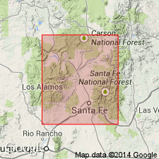
Area of report is northeast plateau, Espanola basin, which is northernmost Rio Grande rift basin, Rio Arriba and Santa Fe Cos, NM in San Juan and Estancia basins. As a result of author's recent mapping and radiometric dating, sedimentary rocks previously mapped (Miller and others, 1963) as the Pleistocene Ancha Formation and part of the underlying Miocene Tesuque Formation have been reassigned to (ascending): 1) Cejita Member of Tesuque Formation; 2) a piedmont facies of Tesuque Formation (containing a pumice layer dated at 10.8 m.y.); 3) high surface gravel deposits of Pliocene to early Pleistocene age; and 4) Quaternary gravel deposits (including the Santa Barbara, Santa Cruz, and Chamisal gravel deposits). Use of term Ancha Formation for the varied gravel deposits is considered inappropriate and is not used in this report.
Source: GNU records (USGS DDS-6; Denver GNULEX).
For more information, please contact Nancy Stamm, Geologic Names Committee Secretary.
Asterisk (*) indicates published by U.S. Geological Survey authors.
"No current usage" (†) implies that a name has been abandoned or has fallen into disuse. Former usage and, if known, replacement name given in parentheses ( ).
Slash (/) indicates name conflicts with nomenclatural guidelines (CSN, 1933; ACSN, 1961, 1970; NACSN, 1983, 2005, 2021). May be explained within brackets ([ ]).