The National Geologic Map Database is migrating to a new infrastructure. We apologize for any service disruptions during this process.
|
|---|


- Usage in publication:
-
- Cedar Vale shale bed
- Modifications:
-
- Original reference
- Dominant lithology:
-
- Shale
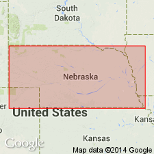
- AAPG geologic province:
-
- Nemaha anticline
Summary:
Pg. 53. Cedar Vale shale bed of Scranton shale member of Shawnee group. The Nebraska Geol. Survey now restricts White Cloud shale of Condra (1927, Nebraska Geological Survey Bull., 2nd ser., no. 1) to that part of Scranton shale below Happy Hollow limestone and applies Cedar Vale shale to interval between Rulo limestone above and Happy Hollow limestone below. Age is Pennsylvanian.
Type locality: east of Cedar Vale, Chautauqua Co., KS.
Source: US geologic names lexicon (USGS Bull. 896, p. 384); GNC KS-NE Pennsylvanian Corr. Chart, sheet 1, Oct. 1936; supplemental information from GNU records (USGS DDS-6; Denver GNULEX).

- Usage in publication:
-
- Cedar Vale shale
- Modifications:
-
- Revised
Summary:
Pg. 212. Cedar Vale shale. Rank raised to formation in Wabaunsee group. Is bluish to yellowish brown, includes clayey and sandy beds, and, near top, the Elmo coal. Thickness averages 25+/- feet. Is traceable from southern Nebraska to northern Oklahoma. Is exposed in east bluff of Caney River, sec. 12, T. 34 S., R. 8 E., Chautauqua County, Kansas. Overlies Happy Hollow limestone and underlies Rulo limestone. [Moore discarded Scranton shale and treated this shale as a formation in his redefined Wabaunsee group.] Age is Late Pennsylvanian (Virgil).
See also "Modern classifications of the Pennsylvanian rocks of eastern Kansas and southeastern Nebraska," compiled by M.G. Wilmarth, Secretary of Committee on Geologic Names, USGS unpub. corr. chart, Oct. 1936, sheet 2.
Source: US geologic names lexicons (USGS Bull. 896, p. 384; USGS Bull. 1200, p. 692); GNC KS-NE Pennsylvanian Corr. Chart, sheet 2, Oct. 1936.
- Usage in publication:
-
- Cedar Vale shale
- Modifications:
-
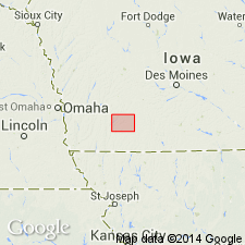
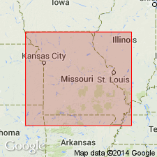
- Areal extent
- Dominant lithology:
-
- Shale
- Clay
- AAPG geologic province:
-
- Forest City basin
Summary:
Pg. 309 (fig. 14). Cedar Vale shale. Stratigraphic section shows occurrence in Adams County, southeastern Iowa. Age is Late Pennsylvanian (Virgilian).
Source: US geologic names lexicon (USGS Bull. 1200, p. 692).

- Usage in publication:
-
- Cedar Vale shale member*
- Modifications:
-
- Revised
Summary:
Pg. 2274 (fig. 1), 2277. Cedar Vale shale member of Scranton shale. Rank reduced to member status in Scranton shale here reintroduced as a formation with stratigraphic span as assigned to it by Haworth and Bennett (1908). Underlies Rulo limestone member; overlies Happy Hollow limestone member. Age is Late Pennsylvanian (Virgilian).
Source: US geologic names lexicon (USGS Bull. 1200, p. 692).

- Usage in publication:
-
- Cedar Vale shale
- Modifications:
-
- Areal extent
Summary:
Pg. 14, fig. 5. Cedar Vale shale of Wabaunsee group is marked by Elmo coal at top. Shale is gray and blocky and contains nodular limestone near top and center. Thickness 18 feet in drillhole near Coin [Iowa]. Overlies Happy Hollow limestone; underlies Silver Lake shale. Rulo limestone, which underlies Silver Lake in some areas has not been identified in Iowa. Age is Late Pennsylvanian (Virgilian).
Source: US geologic names lexicon (USGS Bull. 1200, p. 692).

- Usage in publication:
-
- Cedar Vale Shale Member
- Modifications:
-
- Overview
Summary:
(Paleozoic Era; Pennsylvanian System by J.M Jewett, H.G. O'Connor, and D.E. Zeller, p. 40.) Cedar Vale Shale Member of Scranton Shale of Sacfox subgroup [informal] of Wabaunsee Group. In Kansas, bluish-gray to yellowish-brown clayey and sandy shale and sandstone containing the persistent Elmo coal bed near top. Topmost beds fossiliferous (mollusks, brachiopods, bryozoans). Thickness about 16 to 60 feet. Occurs above Happy Hollow Limestone Member and below Rulo Limestone Member, both of Scranton Shale. Age is Late Pennsylvanian (Virgilian).
["Subgroup" not recognized as a formal stratigraphic rank term (CSN, 1933; ACSN, 1961, 1970; NACSN, 1983, 2005, 2021). Considered informal and should not be capitalized.]
Source: Publication.
- Usage in publication:
-
- Cedar Vale Shale Member
- Modifications:
-
- Overview
Summary:
Pg. 127 (fig. 37), 129. Cedar Vale Shale Member of Scranton Formation of Sacfox subgroup [informal] of Wabaunsee Group. In northwestern Missouri, composed mostly of gray shale, which contains clay-ironstone concretions. The Elmo coal bed and its associated underclay occur at top. Thickness 10 and 15 feet. Age is Late Pennsylvanian (Virgilian).
["Subgroup" not recognized as a formal stratigraphic rank term (CSN, 1933; ACSN, 1961, 1970; NACSN, 1983, 2005, 2021). Considered informal and should not be capitalized.]
Source: Publication.
For more information, please contact Nancy Stamm, Geologic Names Committee Secretary.
Asterisk (*) indicates published by U.S. Geological Survey authors.
"No current usage" (†) implies that a name has been abandoned or has fallen into disuse. Former usage and, if known, replacement name given in parentheses ( ).
Slash (/) indicates name conflicts with nomenclatural guidelines (CSN, 1933; ACSN, 1961, 1970; NACSN, 1983, 2005, 2021). May be explained within brackets ([ ]).