

- Usage in publication:
-
- Cedar Cove formation*
- Modifications:
-
- Named
- Dominant lithology:
-
- Argillite
- Limestone
- AAPG geologic province:
-
- Alaska Southeastern region
Summary:
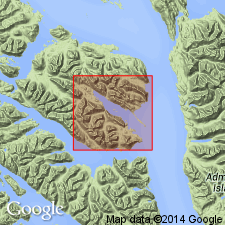
Named from Cedar Cove on southwest shore of Freshwater Bay. Measured type section extends from point on west shore of Cedar Cove, about due west of north tip of Cedar Island, northwestward along shore for about 3 mi, southeastern AK. Divided into lower member of dominantly thin-bedded argillite and upper member of dominantly limestone at type section. Is 2660 ft thick. Overlies Kennel Creek limestone (new). Unconformably underlies Freshwater Bay formation (new). Shown on geologic map of Freshwater Bay area, Chichagof Island, AK. Age is considered Middle and Late(?) Devonian based on fossils.
Source: GNU records (USGS DDS-6; Menlo GNULEX).
- Usage in publication:
-
- Cedar Cove Formation*
- Modifications:
-
- Age modified
- Areal extent
- AAPG geologic province:
-
- Alaska Southeastern region
Summary:
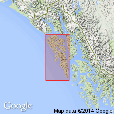
Shown on geologic map of Chichagof, Baranof, and Kruzof Islands, southeastern AK. Unit is extended to outcrops along Chatham Strait on north shore of Tenakee Inlet, in Hoonah area, and throughout region between Port Frederick and Icy Strait. Upper limestone member exposed in Port Frederick-Icy Strait area shown separately on map. Also lower clastic member (up to 3000 ft thick) shown separately from Cedar Cove Formation undivided. Age is Middle and Late Devonian based on fossil evidence (CYRTOSPIRIFER fauna of Frasnian age identified by J.T. Dutro, Jr., written commun., 1958).
Source: GNU records (USGS DDS-6; Menlo GNULEX).
For more information, please contact Nancy Stamm, Geologic Names Committee Secretary.
Asterisk (*) indicates published by U.S. Geological Survey authors.
"No current usage" (†) implies that a name has been abandoned or has fallen into disuse. Former usage and, if known, replacement name given in parentheses ( ).
Slash (/) indicates name conflicts with nomenclatural guidelines (CSN, 1933; ACSN, 1961, 1970; NACSN, 1983, 2005, 2021). May be explained within brackets ([ ]).