The National Geologic Map Database is migrating to a new infrastructure. We apologize for any service disruptions during this process.
|
|---|


- Usage in publication:
-
- Cedar Breaks Formation
- Modifications:
-
- Named
- Dominant lithology:
-
- Limestone
- Sandstone
- Conglomerate
- AAPG geologic province:
-
- Great Basin province
- Paradox basin
- Plateau sedimentary province
- Wasatch uplift
Summary:
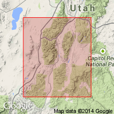
Named; derivation of name not stated though probably for Cedar Breaks National Park [Monument] where unit is best displayed. Type section designated along topographic noses in secs. 23, 27, T36N, R9W, Iron Co, UT. Forms "Pink Cliffs" at Cedar Breaks [Great Basin province], Bryce Canyon National Park and along margins of Table Cliff Plateau, Garfield and Kane Cos [Paradox basin and Plateau sedimentary province]; also exposed on east-facing cliffs of Pavant Mountains, Sevier Co [Wasatch uplift]. Rocks previously referred to as Wasatch Formation in southern High Plateaus and Flagstaff Formation in Pavant Mountains. At type consists of 55% calcilutite, 25% calcisiltite, 14% argillaceous calcilutite, and 6% sandstone and conglomerate; relative percentages vary laterally. Thickness ranges from 1907 ft in Pavant Range, thinning to 1434 ft at type and to 525 ft in Table Cliffs Plateau; pinches out to east. In southern High Plateaus overlies Kaiparowits Formation and underlies Brian Head Formation; in Pavant Mountains overlies North Horn Formation and underlies Green River Formation; contacts are conformable or unconformable. Measured sections; correlation of sections. Cedar Breaks-type rocks probably extend eastward to western part of San Juan Basin; also thought to extend in subsurface westward from Pavant Mountains into Great Basin. Equivalent to Claron Formation and to Flagstaff of Wasatch Plateau. Assigned Paleocene and earliest Eocene age based on correlation with Flagstaff.
Source: GNU records (USGS DDS-6; Denver GNULEX).
- Usage in publication:
-
- Cedar Breaks Formation*
- Modifications:
-
- Not used
Summary:
Not used in this report in Paradox basin. Beds formerly assigned to Cedar Breaks now called pink limestone member of Wasatch Formation. Both Cedar Breaks and Wasatch are of Paleocene and early Eocene age.
Source: GNU records (USGS DDS-6; Denver GNULEX).
For more information, please contact Nancy Stamm, Geologic Names Committee Secretary.
Asterisk (*) indicates published by U.S. Geological Survey authors.
"No current usage" (†) implies that a name has been abandoned or has fallen into disuse. Former usage and, if known, replacement name given in parentheses ( ).
Slash (/) indicates name conflicts with nomenclatural guidelines (CSN, 1933; ACSN, 1961, 1970; NACSN, 1983, 2005, 2021). May be explained within brackets ([ ]).