The National Geologic Map Database is migrating to a new infrastructure. We apologize for any service disruptions during this process.
|
|---|


- Usage in publication:
-
- Cat Hill Formation
- Modifications:
-
- Original reference
- Dominant lithology:
-
- Sand
- Mud
- AAPG geologic province:
-
- Atlantic Coast basin
Summary:
Pg. 2-6. Cat Hill Formation [of Chesapeake Group]. Occurs only in subsurface. Is dominantly sand with minor beds of mud (mixtures of silt and clay). Includes Manokin aquifer. Informally subdivided into (ascending): subunit A, coarsening upward gray, blue-gray, and brown-gray, fine to medium silty quartzose sand and clayey fine sand; and subunit B, light- to medium-gray or yellow-orange to red-orange (where weathered), medium to coarse gray quartzose sand with beds of gravelly coarse sand. Total apparent thickness 100 to 105 feet. Lies above St. Marys Formation and below Bethany Formation (new); both of the Chesapeake Group. Replaces Andres' (1986) †"Manokin formation" and Owens and Denny's (1979) †"Manokin beds," to avoid confusion with aquifer name. Age is considered late middle Miocene (Owens and Denny, 1979; Hansen, 1981; Benson, 1990) to perhaps Pliocene (Miller and others, 2003). Age poorly constrained due to general lack of diagnostic fossils or other materials that can be age-dated.
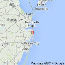
Type locality (subsurface; composite): 3 drillholes in vicinity of Cat Hill, near town of Bethany Beach, eastern Sussex Co., southern DE:
(1) depth-interval 320 to 420 ft, DGS drillhole Qj41-02, Lat. 38 deg. 31 min. 25 sec. N., Long. 75 deg. 04 min. 03 sec. W.;
(2) depth-interval 315 to 420 ft, DGS drillhole Qj41-04, Lat. 38 deg. 31 min. 22 sec. N., Long. 75 deg. 04 min. 05 sec. W.;
(3) depth-interval 320 to 400+ ft, DGS drillhole Qj42-05, Lat. 38 deg. 31 min. 37 sec. N., Long. 75 deg. 03 min. 26 sec. W.
Reference sections (subsurface):
(1) depth-interval 65 to 95 ft, DGS drillhole Oc14-27, Lat. 38 deg. 44 min. 13 sec. N.;
(2) depth-interval 173 to 310 ft, DGS drillhole Oh25-02, Lat. 38 deg. 43 min. 50 sec. N., Long. 75 deg. 10 min. 14 sec. W.;
(3) depth-interval 180 to 255 ft, DGS drillhole Pg53-14, Lat. 38 deg. 35 min. 24 sec. N., Long. 75 deg. 17 min. 42 sec. W.;
(4) depth-interval 90 to 180 ft, DGS drillhole Qd52-02, Lat. 38 deg. 30 min. 40 sec. N., Long. 75 deg. 33 min. 16 sec. W.
Source: Publication.
For more information, please contact Nancy Stamm, Geologic Names Committee Secretary.
Asterisk (*) indicates published by U.S. Geological Survey authors.
"No current usage" (†) implies that a name has been abandoned or has fallen into disuse. Former usage and, if known, replacement name given in parentheses ( ).
Slash (/) indicates name conflicts with nomenclatural guidelines (CSN, 1933; ACSN, 1961, 1970; NACSN, 1983, 2005, 2021). May be explained within brackets ([ ]).