The National Geologic Map Database is migrating to a new infrastructure. We apologize for any service disruptions during this process.
|
|---|


- Usage in publication:
-
- Castle conglomerate
- Modifications:
-
- Original reference
- Dominant lithology:
-
- Conglomerate
- AAPG geologic province:
-
- Denver basin
Summary:
Pg. 96-109. Castle conglomerate. Youngest formation in Castle Rock region, eastern Colorado. Consists of massive compact conglomerate overlying the lava and having maximum thickness of 90 feet. Contains fragments (some 5 feet diameter) of rhyolite from the underlying flow and is composed of coarse, angular, subangular and rounded masses firmly set in finer material. Is upper part of Monument Creek group of Hayden, which is here divided into Castle conglomerate above and Monument Creek formation restricted below.
Named from typical development on Castle Rock butte [Douglas Co.], eastern CO.
Source: US geologic names lexicon (USGS Bull. 896, p. 366-367).
- Usage in publication:
-
- Castle Rock conglomerate*
- Modifications:
-
- Revised
- AAPG geologic province:
-
- Denver basin
Summary:
Pg. 267-276. Castle conglomerate of Lee [preoccupied] is here named Castle Rock conglomerate. It is of Oligocene age, has maximum thickness of 300 feet, and unconformably overlies Dawson arkose (Eocene and 2,000 feet thick). The Castle Rock and Dawson comprise Monument Creek group of Hayden [and Dawson replaces Monument Creek formation restricted of Lee].
Source: US geologic names lexicon (USGS Bull. 896, p. 366-367).
- Usage in publication:
-
- Castle Rock Conglomerate*
- Modifications:
-
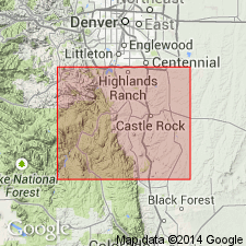
- Mapped 1:24k (Parker quad, Arapahoe and Douglas Cos, CO)
- Dominant lithology:
-
- Conglomerate
- Sandstone
- AAPG geologic province:
-
- Denver basin
Summary:
Is Oligocene formation mapped in northern Douglas Co, CO (Denver basin). Unconformably overlies upper part of Dawson Arkose (Paleocene); older than Slocum Alluvium (Pleistocene). Unit described as mostly grayish-orange-pink to yellowish-gray rock fragments ranging in size from 1/8 in. to 4 ft in diameter, in matrix of fine- to coarse-grained sandstone. Chaotically bedded; poorly to well cemented; locally deeply weathered. Forms flat to gently rolling highlands in southwestern part of quad. Thickness is 10-60 ft.
Source: GNU records (USGS DDS-6; Denver GNULEX).
- Usage in publication:
-
- Castle Rock Conglomerate*
- Modifications:
-
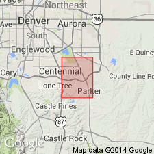
- Mapped 1:24k (Highlands Ranch quad, Arapahoe and Douglas Cos, CO)
- Dominant lithology:
-
- Gravel
- Sandstone
- AAPG geologic province:
-
- Denver basin
Summary:
Is Oligocene formation mapped in northern Douglas Co, CO (Denver basin). Unconformably overlies upper part of Dawson Arkose (Paleocene); unconformably underlies Slocum Alluvium (Pleistocene). Unit described as cemented bouldery gravel and cobbly sandstone; cross-bedded, poorly sorted. Occurs only in upland areas in southeast part of quad. Is up to 40 ft thick.
Source: GNU records (USGS DDS-6; Denver GNULEX).
For more information, please contact Nancy Stamm, Geologic Names Committee Secretary.
Asterisk (*) indicates published by U.S. Geological Survey authors.
"No current usage" (†) implies that a name has been abandoned or has fallen into disuse. Former usage and, if known, replacement name given in parentheses ( ).
Slash (/) indicates name conflicts with nomenclatural guidelines (CSN, 1933; ACSN, 1961, 1970; NACSN, 1983, 2005, 2021). May be explained within brackets ([ ]).