The National Geologic Map Database is migrating to a new infrastructure. We apologize for any service disruptions during this process.
|
|---|


- Usage in publication:
-
- Cariblanco Formation*
- Modifications:
-
- Named
- Dominant lithology:
-
- Siltstone
- Sandstone
- Conglomerate
- Limestone
- Tuff
- Lava
- AAPG geologic province:
-
- Caribbean region
Summary:
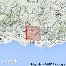
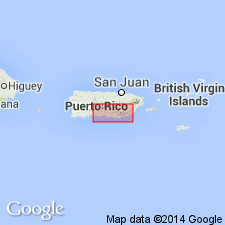
The Cariblanco Formation, here named, consists of thin- to medium-bedded siltstone and sandstone that intertongues with massive conglomerate. Units of limestone, tuff, and lava in the formation are named, in order of decreasing age, the La Guaba Lava Member, the Hacienda Larga Tuff Member, the Jobo Dulce Limestone Member, the Lio Juan Limestone Member, and the Sabana Hoyos Limestone Member. Overlies the Robles Formation; underlies the Coamo Formation. Age is Late Cretaceous.
Source: GNU records (USGS DDS-6; Reston GNULEX).
- Usage in publication:
-
- Cariblanco Formation*
- Modifications:
-
- Revised
- AAPG geologic province:
-
- Caribbean region
Summary:
The uppermost Sabana Hoyos Limestone Member is here removed from the Cariblanco Formation and is included as a member of the overlying Maravillas Formation. In the Coamo area the Cariblanco includes the La Guaba Lava Member near the base and the Jobo Dulce and Pio Juan Limestone Members in the upper part. The Hacienda Larga Tuff Member originally named in the Coamo quadrangle in the belief that it was a unique isochronous rock unit, has been shown to be merely a rather pure accumulation of a crystal tuff component of the matrix. Specific correlation of the crystal tuff mapped at Hacienda Larga south of the Rio Cuyon with the Hacienda Larga Member mapped north of the Rio Cuyon is not implied.
Source: GNU records (USGS DDS-6; Reston GNULEX).

- Usage in publication:
-
- Cariblanco Formation*
- Modifications:
-
- Overview
- AAPG geologic province:
-
- Caribbean region
Summary:
The Cariblanco Formation occurs in central Puerto Rico and consists of volcaniclastic conglomerate, sandstone, siltstone, lava and limestone. Conglomerate is dominantly composed of hornblende dacite welded ash-flow tuff, amygdaloidal plagioclase-pyroxene biotite andesite, and subordinate sandstone, siltstone, and limestone clasts. Maximum estimated thickness is 1000 meters. The Cariblanco is of Late Cretaceous age.
Source: GNU records (USGS DDS-6; Reston GNULEX).
For more information, please contact Nancy Stamm, Geologic Names Committee Secretary.
Asterisk (*) indicates published by U.S. Geological Survey authors.
"No current usage" (†) implies that a name has been abandoned or has fallen into disuse. Former usage and, if known, replacement name given in parentheses ( ).
Slash (/) indicates name conflicts with nomenclatural guidelines (CSN, 1933; ACSN, 1961, 1970; NACSN, 1983, 2005, 2021). May be explained within brackets ([ ]).